- Remove Small landforms filter Small landforms
- Remove Middle age filter Middle age
- Remove Maritime environments filter Maritime environments
- Remove Bronze age filter Bronze age
- Remove Jondal, frå 2020 del av nye Ullensvang kommune. filter Jondal, frå 2020 del av nye Ullensvang kommune.
- Remove Lindås, frå 2020 del av nye Alver kommune. filter Lindås, frå 2020 del av nye Alver kommune.
- Remove Odda, frå 2020 del av nye Ullensvang kommune. filter Odda, frå 2020 del av nye Ullensvang kommune.
- Remove Farming and forestry filter Farming and forestry

Bakko
Everyone knows the famous painting by Tidemand & Gude “Brudeferden i Hardanger” (The Wedding Party in Hardanger) one of the great icons in the National Gallery. Some have, in a humorous lack of respect for this masterpiece linked the concept of “bride’s passage” to another pictorial presentation in Hardanger. This is found on the farm Bakko in Herand, carved in the rock by an unknown artist around 3,000 years ago.


Svåsand
Down by the fjord at Svåsand, close to the main highway, there is a long row of boathouses, one of the well-preserved, older boathouse locations along the Hardanger fjord. It is the farms at Svåsand that have their boathouses here, four main farms with origins far back in time.

Lurekalven
Lurekalven is an unpopulated island of heather moor which is a part of the wilderness belonging to the five farms on Ytre Lygra. Between the two islands there is only a small sound. As late as the 1920s, milking cows were rowed over the sound from Lygra in summer – a form of farming that was adapted to the coastal landscape.

Lygra
The heath landscape on outer Lygra, Utluro and Lurekalven will in future become part of a landscape protection area, to be maintained through traditional activities with year-round outdoor sheep, grazing and burning. The West Norwegian heath country belongs to a large North Atlantic coastal landscape stretching from the Bay of Biscay to the Lofoten islands.

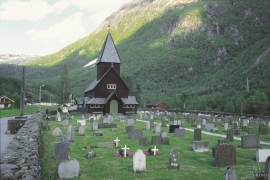
Røldal
The stave church in Røldal was one of the key pilgrimage churches in West Norway. The church was probably built between 1250 and 1350, and in the high Middle Ages Røldal was the most important destination for pilgrims in the country beside the Nidaros cathedral. It was the crucifix that attracted people to midnight mass on midsummer night. That was when it excreted its miraculous sweat.

