- Remove Small landforms filter Small landforms
- Remove Middle age filter Middle age
- Remove Maritime environments filter Maritime environments
- Remove Defense filter Defense
- Remove Voss, frå 2020 del av nye Voss herad. filter Voss, frå 2020 del av nye Voss herad.
- Remove Churches filter Churches
- Remove Wetland filter Wetland
- Remove Vernacular crafts filter Vernacular crafts

Evanger
Evanger (from Old Norse ålvangr, “vang”, “voll” (field) where the horses may graze) is the place where the river from Vangsvatnet, the Voss watercourse, runs out into Evangervatnet. From here Teigdalen valley runs to the north, towards Eksingedalen, and from here there is a short distance to Bergsdalen in the south.

Finne
Peter Bonde, who owned Finne towards the end of the 1200s, had a jumping stag in his family emblem. This stag is the origin for the heraldic blazon of Voss. Peter Bonde and his descendants acquired possession of many farms and farm parts; the so-called Finne properties became some of the largest land properties in the country.


Oppheim
In the slope above Oppheim church lies the old vicarage at OPPHEIM. If you stroll up the road from the church you will arrive in a farmyard marked by traces of building style and living traditions from the Middle Ages.
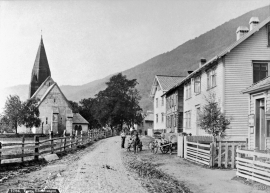
Vangskyrkja
Vangskyrkja (Vangen church) is the largest of the medieval churches in Hordaland; one of the four “fjordung” churches in the county. A royal letter from 1271 shows that the church was under construction at this time. Vossevangen at Vangsvatnet, where the wide and expansive valleys of the Voss communities meet, was the natural location for a church.

Ringheim
The farm Ringheim by Lundarvatnet is amongst the largest in Voss. It is divided into eight units and four cadastral numbers: Store Ringheim, Indre Ringheim, Nedre Ringheim and Vetle Ringheim. The farm Lund, from which Lundarvatnet takes its name, must have been a part of Ringheim, and the farms Gjerde and Tròdo (Trå) must formerly have been separated from Ringheim. The name Ringheim indicates that it stems from early times.

Bordalsgjelet
Deep down between the stone polished phyllite bedrock in Bordalsgjelet canyon, there is a cascading river. In close cooperation with hard polishing stones, the water has carved into the bedrock for thousands of years - and is still doing so today.


Lønaøyane
The Strandaelvi river is forever protected from the development of hydropower. The Lønaøyane islands – which comprise the delta furthest north in Lake Lønavatnet - are a part of this water system. In 1995 the level of protection for the Lønaøyne islands was strengthened to that of a nature preserve because of the rich birdlife in this wetland.

