- Remove Small landforms filter Small landforms
- Remove Middle age filter Middle age
- Remove Conservation area filter Conservation area
- Remove Late glacial filter Late glacial
- Remove Fitjar filter Fitjar
- Remove Odda, frå 2020 del av nye Ullensvang kommune. filter Odda, frå 2020 del av nye Ullensvang kommune.
- Remove Museum filter Museum
- Remove Modalen filter Modalen

Mostraumen
Until 1743 the people from Modal had to wait for a flood in MOSTRAUMEN before they could draw their boats up the river current, and then row back across Lake Movatnet. But, that year the flood opened a free passageway all the way to Mo. Hordaland had gained a new tidal waterway.

Nedre Helland- Sand Quarries
The three spades in the municipal coat of arms for Modalen are sand spades. Sand quarrying has brought income and employment. As much as 70,000-80,0000 tonnes of sand and gravel left the municipality each year since the turn of the millennium, to be used as cementing sand. Why is Modalen endowed with so much sand?

Nottveit
In one of the frame-built haysheds at Nottveit, at holding No. 3, we discover that several of the staves have a medieval look, with large dimensions and carefully rounded edges. According to tradition, it was the farms Nottveit and Mostraumen that supplied the timber for the stave church at Mo, and it is not unlikely that these farms received the old timber in return when the new church was erected there in 1593.

Otterstadstølen
Otterstadstølen lies in an idyllic grassy plain surrounded by rich forest, but also with high mountains close by. The mountainsides are steep and typical of this part of the county. The same cannot be said about the forest. This spruce forest has been able to develop freely for hundreds of years. Otherwise in the county, only Voss has spruce forest.

Stølsheimen
The large mountain area between Modalen, the Voss communities and Sogn is one of the finest mountain pasture areas in West Norway. In older times this area was called Steinslandsheimen, in our times it has acquired the name Stølsheimen. Power development and protection interests have been opposed here. The core area of Stølsheimen has now been protected as a landscape protection area, while some of the oldest mountain farms have been flooded. A register in the 1970s comprised almost 40 mountain farm settlements in the central area of Stølsheimen, belonging to Modalen, Høyanger and Vik municipalities.


Fitjar- potatoes
The deep agricultural soils in Fitjar are found especially in the area between Lake Storavatnet and Breivika. The many stonewalls in the area reflect that the earth probably was full of stones and stone blocks. The stones that couldn't be dug out had also a function: they stored heat that helped to grow potatoes.

Rimbareid- Vestbøstad
At nesting time you cannot avoid hearing the calls of the curlew or the snipe along the narrow road through the cultural landscape from Rimbareid to Vestbøstad. And on late summer evenings, the intense song of the sedge warbler rings out over the two characteristic tarns in the area.

Årskog
Årskog farm is situated in a typical coastal landscape in a gentle terrain that slopes down from the outlying heaths down towards the fjord. The farm steading exists as it was in the 1800s. In 1980 the two brothers, Lars and Olai Årskog donated the farm with all its contents of tools and interior decoration, for museum purposes.
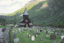
Røldal
The stave church in Røldal was one of the key pilgrimage churches in West Norway. The church was probably built between 1250 and 1350, and in the high Middle Ages Røldal was the most important destination for pilgrims in the country beside the Nidaros cathedral. It was the crucifix that attracted people to midnight mass on midsummer night. That was when it excreted its miraculous sweat.

