- Remove Small landforms filter Small landforms
- Remove Maritime environments filter Maritime environments
- Remove Modalen filter Modalen
- Remove Øygarden, frå 2020 del av nye Øygarden kommune. filter Øygarden, frå 2020 del av nye Øygarden kommune.
- Remove Granvin, frå 2020 del av nye Voss herad filter Granvin, frå 2020 del av nye Voss herad
- Remove Sediments filter Sediments
- Remove Osterøy filter Osterøy
- Remove Os, frå 2020 del av nye Bjørnafjorden kommune filter Os, frå 2020 del av nye Bjørnafjorden kommune
- Remove Conservation area filter Conservation area

Granvinsvassdraget
After the ice age, Granvin Fjord reached all the way up under Skjervsfjossen waterfall. Just a thousand years later, as a result of the rising of the land after the ice melted, this whole inner part of the fjord freed itself of the sea and became Granvinsvatnet lake. In spite of this rise in elevation, this waterway is still navigable for fish: Sea trout have wandered into Granvinsvatnet in more recent times and evolved to become freshwater trout. And salmon and sea trout made the journey 13 kilometres up the Storelvi river.


Joberget
Flowering lime is one of nature's blessings: The nectar gives clear honey. The flower is used as folk medicine. From the inner bark of the lime tree one can make strong rope. Elderly folk can still tell how they got a weather report from the lime tree. If it smelled strong, it was probably going to rain. Lime often grows together with elm, ash and other tree species of the deciduous forest. Pure lime forests are rarer. Granvin has Hordaland's biggest lime forests.

Uranes
One of the most magnificent deciduous forests in Hordaland grows along the border with Kvam. The rich growth comes from the phyllite and mica schist bedrock, together with a good climate. Along the fjord the summer is warm but not too dry, and in winter it is not too cold for plants that do not tolerate the frost.


Hjelmo
On the farm Hjelmo, furthest north in Øygarden, in the innermost part of a long bay, there is a fine boatshed collection with a church beside it. From times immemorial this has probably been the fish-shed location for these farm units and this was also the landing place for the churchgoers.
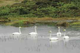
Tjeldstømarka
There is no place in Hordaland where there are so many over-wintering song swans as in Tjeldstømarka. And there are few places in the county that have had this birdfowl as a guest for as long.

Mostraumen
Until 1743 the people from Modal had to wait for a flood in MOSTRAUMEN before they could draw their boats up the river current, and then row back across Lake Movatnet. But, that year the flood opened a free passageway all the way to Mo. Hordaland had gained a new tidal waterway.

Nedre Helland- Sand Quarries
The three spades in the municipal coat of arms for Modalen are sand spades. Sand quarrying has brought income and employment. As much as 70,000-80,0000 tonnes of sand and gravel left the municipality each year since the turn of the millennium, to be used as cementing sand. Why is Modalen endowed with so much sand?

Otterstad
Tthe Otterstad farms lie in the innermost part of Mofjorden, on the northwest side of the river. The row of stave-built boatsheds that belong to the farm were probably constructed a little after the middle of the 1800s. Both here and on the Mo side, the boatsheds were important storage places at the seashore; wood and other farm products intended for the town; corn and merchandise in return.

