- Remove Small landforms filter Small landforms
- Remove Thrust sheets filter Thrust sheets
- Remove Coniferous forests filter Coniferous forests
- Remove Middle age filter Middle age
- Remove Bronze age filter Bronze age
- Remove Faults filter Faults
- Remove Etne filter Etne
- Remove Kvam filter Kvam

Helgaberget
Helgaberget – the holy hill – is a little rocky crag which thrusts itself a few metres above the terraced surface of Støle. The surface of the rock is strewn with figures inscribed in the rock and it was, as far as one can judge, a cult centre in the Bronze Ages. The name could indicate that the tradition of holiness can have lasted for almost 3,000 years.


Støle church
The stone church at Støle may have been built around 1160 probably as a private chapel for the mighty Stødle clan. It is likely that it was Erling Skakke, the king’s representative and father of king Magnus Erlingsson, who built the church.

Kvamskogen
The different bedrock types that got shoved in over Hordaland in Cambro-Silurian times still remain, layer by layer, almost like a cake. But at Kvamskogen the cake has been turned upside down.
Vangdal
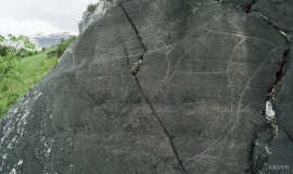
At Salthamaren in Vangdalsberget it is thought that salt was burned some time in history, and deep layers of coal in the ground show that fire has been made up here several times. But they were hardly salt-burners, the first people who stopped here. Some of them carved figures into the rock. On top of the rocky outcrop, furthest out on the cliff, a group of Stone Age hunters carved animal figures. More than 1,500 years later Bronze Age farmers drew ship figures at the foot of the rock. Both these works of art - some of the oldest in Hordaland – are still visible, carved in the rock at Salthamaren.

Vesoldo
Folds are to be found everywhere in the remains of the Caledonian mountain chain. Some were formed during the collision with Greenland, others stem from the time when the mountain chain collapsed. Few can compare with the giant fold that remains in the mountain area around Tørvikenuten, Vesoldo and Hellefjellet.

Krokavatnet
On Sunday the 29th of January, 1989, at 17:38 o'clock, Etna shook. The earthquake, with its epicentre ca. 9 kilometres south of Etne centre, had a strength of 4.2 on the Richters scale. This could be felt over large parts of West Land, especially in the areas around Åkra, Etne, Hardanger Fjord and Sauda Fjord. The earthquake was the largest that has ever been measured in Hordaland.

Mosnes
The permanently-protected Mosneselva River, with its meltwater from Folgefonna, runs out into Åkra Fjord by the roadless and uninhabited Mosnes. Those who once lived here were forced to surrender to the ravages of Nature. In the autumn of 1962 there was a flood so great that the people were driven from their farms.

