- Remove Small landforms filter Small landforms
- Remove Eidfjord filter Eidfjord
- Remove Stord filter Stord
- Remove Modalen filter Modalen
- Remove Churches filter Churches
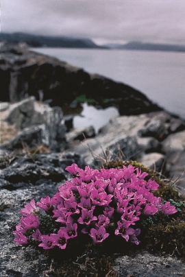
- Remove Plants by the sea filter Plants by the sea
- Remove Road constructions filter Road constructions
- Remove Large landforms filter Large landforms
- Remove Osterøy filter Osterøy

Agastølen
Whoever wanders the mountain plateau will form time to time hit upon old mountain summer farms, with solid old stone sheds, half sunk into the ground; a building tradition that has roots into prehistoric times. When we have been satiated with untouched Nature, it is somewhat comforting to come upon the old mountain chalets - they represent a type of human encroachment that we not only accept, but appreciate. They arouse a feeling of recognition and are a distinct witness to how people in the rural communities have made use of even the most remote resources.

Måbødalen- geology
The old pack road had 1500 steps, where cars today gas through the mountain. The time of this hard work is over, and of getting used to the steep terrain, as well; only the view from the top is much the same as before. Vøringsfossen in summer is one of Western Norway’s biggest natural wonders. It marks the transition between the older, open part of the Sysendalen valley and the younger, narrow and winding valley of Måbødalen.


Hamre Church
Hamre Church has, by all accounts been one of the four main churches in Horda County in the Middle Ages. Hamre was a main church for the whole of Hordaland. Timber remains in the present church show that there was a stave church here in medieval times.

Hosanger church
On Christmas Day 1795, at 5 a.m., the lightning struck the church in Hosanger. After three hours, the timbered church from the 1600s, which had replaced the stave church from the Middle Ages, was in ashes. Already on New Years Day in 1796, a sermon was held for the Hosanger population in the main church at Hamre, to which the congregation belonged earlier,


Huglo
The majority of Huglo is bare rock. A bit of dwarf pine forest is the only vegetation able to put down roots. Along the west- and east sides, to the contrary, the landscape is unusually green and lush. The reason lies both in the bedrock and in the ice that covered the area 12 000 years ago.

Kattnakken–Stovegolvet
The highest mountainous area on Stord, including Kattnakken, Midtfjellet and Stovegolvet, has more in common with the mountainous terrain on the mainland than in the low coastal landscape of Sunnhordland. The volcanic bedrock together with the erosive powers of nature has resulted in a unique plateau landscape.

