- Remove Small landforms filter Small landforms
- Remove Aristocracy and civil servants filter Aristocracy and civil servants
- Remove Tourism filter Tourism
- Remove Kvinnherad filter Kvinnherad
- Remove Fitjar filter Fitjar
- Remove Faults filter Faults
- Remove Sund, frå 2020 del av nye Øygarden kommune filter Sund, frå 2020 del av nye Øygarden kommune
- Remove Maritime environments filter Maritime environments
- Remove Defense filter Defense
- Remove Askøy filter Askøy
- Remove Tysnes filter Tysnes
- Remove Sunnhordland filter Sunnhordland
- Remove Memorial stones filter Memorial stones
- Remove Place filter Place
- Remove Midthordland filter Midthordland
- Remove Middle age filter Middle age

Bondhusdalen
The Bondhus area in Maruanger has been a magnet for tourists ever since the stream of tourists to Norway's west coast began in the middle of the 1800s. The magnificent landscape with the "ice trail" up to Bondhusvatnet Lake, the ice falls from Bondhusbreen glacier and Keisarstigen trail up to Folgefonna are still popular tourist attractions.


Fitjarøyane
If we study the group of islands south of Selbjørns Fjord from the air or on a sea map, we will notice that many of the islands are elongated and lie systematically in rows. The islands are divided by long sounds, for example Trollosen, Nuleia and Hjelmosen, which are oriented in a south-southeast to north-northwesterly direction.


Godøysund
The old hostelry centres were strategically placed with good harbours and anchoring conditions where people travelled. GODØYSUND, or Gøysundet, as it was called, was in the middle of Tysnes Parish, with easy access from the sea, also for the local population. Gøysundet is amongst the oldest hostelries in Sunnhordland.

Golta- Long house
In the years between the wars a major registration of houses and house costumes, house construction methods, fireplaces and forms of housing clusters was started in West Norway – an ambitious mapping of everything that came under the name “Registration of Culture and Geography in West Norway”. One of the places of which material was gathered in 1938 was an old multi-room house at Golta; new and interesting material for the researchers from the Historical Museum, but well known within the local building tradition through several generations.

Goltasundet
For generations the land-seine was the most important tool for catching herring and mackerel, and therefore a suitable casting bay was worth its weight in gold. Goltasundet (the Golta sound) on Golta was such a place. Here the herring often drifted in and fantastic casts might be made here.

Halsnøy Monastery
Halsnøy Monastery is situated in the midst of the lush fjord country in Sunnhordland, on one of the old spits, or “necks”, that has given name to the island. Gently sloping fields lead down to the sea on both sides, in the south towards the Kloster Fjord, to the north towards the sheltered Klostervågen.

Herdla farm
Numerous finds show that the settlement at Herdla goes back to prehistoric times, and the large estate at Herdla has enjoyed a central place in the nation’s history since High Middle Ages. As Ask, Herdla was part of the country estate Harald Hårfagre took over as he took command of the west of Norway.
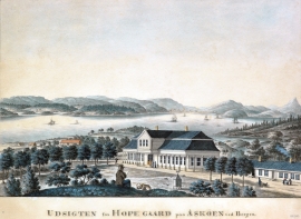
Hop- Thomas Erichsens Minde
From the 1500s Hop was noble estate for the law speaker in Bergen and Gulen judicial districts. Several of the law speakers were of noble descent, such as Hans Hansen Lillienskiold and Niels Knagenhielm. The beautiful main building, still standing, was erected by the Bergen merchant Thomas Erichsen in 1793-95. He also established a magnificent garden with an 800 metres long linden avenue reaching down to the stone boathouse at Hop harbour.

