- Remove Small landforms filter Small landforms
- Remove Farming and forestry filter Farming and forestry
- Remove Stone age filter Stone age
- Remove Vaksdal filter Vaksdal
- Remove Wetland filter Wetland
- Remove Maritime environments filter Maritime environments
- Remove Seabirds filter Seabirds
- Remove Monastery filter Monastery
- Remove Sund, frå 2020 del av nye Øygarden kommune filter Sund, frå 2020 del av nye Øygarden kommune
- Remove Fitjar filter Fitjar
- Remove Osterøy filter Osterøy
- Remove Chieftains and royal lines filter Chieftains and royal lines
- Remove Fisheries filter Fisheries
- Remove Austrheim filter Austrheim

Golta- Long house
In the years between the wars a major registration of houses and house costumes, house construction methods, fireplaces and forms of housing clusters was started in West Norway – an ambitious mapping of everything that came under the name “Registration of Culture and Geography in West Norway”. One of the places of which material was gathered in 1938 was an old multi-room house at Golta; new and interesting material for the researchers from the Historical Museum, but well known within the local building tradition through several generations.

Goltasundet
For generations the land-seine was the most important tool for catching herring and mackerel, and therefore a suitable casting bay was worth its weight in gold. Goltasundet (the Golta sound) on Golta was such a place. Here the herring often drifted in and fantastic casts might be made here.

Skogsvåg
Kval i våg! Når det ropet gjekk, var det berre å få ut den kraftige kvalnota til å stengja vågen med, og så kunne veidinga ta til. I uminnelege tider har det vore drive kvalveiding i Skogsvågen.


Hopland
The farmhouses at holding No. 15 at Hopland are built together to form a long, continuous building, with dwelling house, hayshed and cowshed built in one row. There have been many such joined structures in the coastal communities, but today there are few remaining. If we travel to the other side of the North Sea, to the Faeroes, Shetland and the Orkney Islands, we find corresponding features in the older building traditions. We find ourselves in a large North Atlantic cultural area.

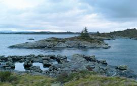
Krossøy
Furthest north in the island community Rongevær, at the entrance to Fensfjorden, lies Krossøy. Belonging to the farm are the islands of Krossøy, Husøy, Kårøy, Lyngkjerringa, Søre Kjerringa, Rotøy and Kuhovet. All of them have been inhabited. On Krossøy itself today there are four holdings. The marine use environment here is one of the best preserved along the West Norwegian coast.

Leirvågen
A marsh is a grassy meadow that is strongly influenced by salt from the sea. This type of nature is abundant in Denmark, among other places. The flatlands along the river that run out by Leirvågen, are the municipalities' largest marsh. At spring tide, these flatlands are flooded underwater for several hundred metres in over land.


