- Remove Small landforms filter Small landforms
- Remove Tourism filter Tourism
- Remove Stord filter Stord
- Remove Samnanger filter Samnanger
- Remove Large landforms filter Large landforms
- Remove Fjell, frå 2020 del av nye Øygarden kommune filter Fjell, frå 2020 del av nye Øygarden kommune
- Remove Maritime environments filter Maritime environments
- Remove Defense filter Defense
- Remove Askøy filter Askøy
- Remove Tysnes filter Tysnes
- Remove Sunnhordland filter Sunnhordland
- Remove Place filter Place
- Remove Midthordland filter Midthordland
- Remove Middle age filter Middle age
- Remove Aristocracy and civil servants filter Aristocracy and civil servants


Fossen Bratte
The steep drop by Fossen cliff has been the biggest challenge for those who wished to make a road over Kvamskogen through the years. Leave the car by the monument on the old road and take a walk down to the bend by the waterfall that Bergen-folk call "The bridal veil". Why is there a waterfall just here?


Godøysund
The old hostelry centres were strategically placed with good harbours and anchoring conditions where people travelled. GODØYSUND, or Gøysundet, as it was called, was in the middle of Tysnes Parish, with easy access from the sea, also for the local population. Gøysundet is amongst the oldest hostelries in Sunnhordland.


Herdla farm
Numerous finds show that the settlement at Herdla goes back to prehistoric times, and the large estate at Herdla has enjoyed a central place in the nation’s history since High Middle Ages. As Ask, Herdla was part of the country estate Harald Hårfagre took over as he took command of the west of Norway.
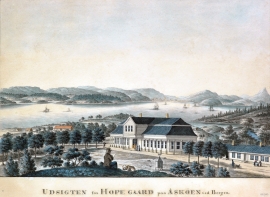
Hop- Thomas Erichsens Minde
From the 1500s Hop was noble estate for the law speaker in Bergen and Gulen judicial districts. Several of the law speakers were of noble descent, such as Hans Hansen Lillienskiold and Niels Knagenhielm. The beautiful main building, still standing, was erected by the Bergen merchant Thomas Erichsen in 1793-95. He also established a magnificent garden with an 800 metres long linden avenue reaching down to the stone boathouse at Hop harbour.

Huglo
The majority of Huglo is bare rock. A bit of dwarf pine forest is the only vegetation able to put down roots. Along the west- and east sides, to the contrary, the landscape is unusually green and lush. The reason lies both in the bedrock and in the ice that covered the area 12 000 years ago.

Høybøen
In connection with the planned developments in the oil sector at Vindenes around 1980, excavations were carried out under the auspices of Bergen Historical Museum. Exceptionally interesting traces of an old farm at Høybøen then came to light. These were the remnants of a farm where there had been two houses containing several rooms.

Kattnakken–Stovegolvet
The highest mountainous area on Stord, including Kattnakken, Midtfjellet and Stovegolvet, has more in common with the mountainous terrain on the mainland than in the low coastal landscape of Sunnhordland. The volcanic bedrock together with the erosive powers of nature has resulted in a unique plateau landscape.

