- Remove Small landforms filter Small landforms
- Remove Faults filter Faults
- Remove Kvinnherad filter Kvinnherad
- Remove Maritime environments filter Maritime environments
- Remove Seabirds filter Seabirds
- Remove Monastery filter Monastery
- Remove Sund, frå 2020 del av nye Øygarden kommune filter Sund, frå 2020 del av nye Øygarden kommune
- Remove Fitjar filter Fitjar
- Remove Osterøy filter Osterøy
- Remove Mineral resources filter Mineral resources
- Remove Mines filter Mines
- Remove Churches filter Churches

Fitjarøyane
If we study the group of islands south of Selbjørns Fjord from the air or on a sea map, we will notice that many of the islands are elongated and lie systematically in rows. The islands are divided by long sounds, for example Trollosen, Nuleia and Hjelmosen, which are oriented in a south-southeast to north-northwesterly direction.

Fjelberg
The beautiful vicarage on the Fjelberg Island lies a few minutes walk up from the fjord, in a compact enclosure with the church south of the main building and the bishop’s residence to the north; a rare harmonic cluster.


Golta- Long house
In the years between the wars a major registration of houses and house costumes, house construction methods, fireplaces and forms of housing clusters was started in West Norway – an ambitious mapping of everything that came under the name “Registration of Culture and Geography in West Norway”. One of the places of which material was gathered in 1938 was an old multi-room house at Golta; new and interesting material for the researchers from the Historical Museum, but well known within the local building tradition through several generations.

Goltasundet
For generations the land-seine was the most important tool for catching herring and mackerel, and therefore a suitable casting bay was worth its weight in gold. Goltasundet (the Golta sound) on Golta was such a place. Here the herring often drifted in and fantastic casts might be made here.

Grønafjellet
Mountain plants with their beautiful, colourful flowers are common in high altitude areas in Norway. On the coast there are not so many of them. But, here and there one nonetheless finds mountain plants, and this makes some coastal mountainsides a little bit different. Perhaps the growth on these mountainsides gives us a little glimpse of a distant past?

Halsnøy Monastery
Halsnøy Monastery is situated in the midst of the lush fjord country in Sunnhordland, on one of the old spits, or “necks”, that has given name to the island. Gently sloping fields lead down to the sea on both sides, in the south towards the Kloster Fjord, to the north towards the sheltered Klostervågen.

Hamre Church
Hamre Church has, by all accounts been one of the four main churches in Horda County in the Middle Ages. Hamre was a main church for the whole of Hordaland. Timber remains in the present church show that there was a stave church here in medieval times.

Hosanger church
On Christmas Day 1795, at 5 a.m., the lightning struck the church in Hosanger. After three hours, the timbered church from the 1600s, which had replaced the stave church from the Middle Ages, was in ashes. Already on New Years Day in 1796, a sermon was held for the Hosanger population in the main church at Hamre, to which the congregation belonged earlier,
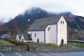
Kvinnherad Church
The stately Kvinnherad Church with its characteristic profile set out against the mighty Malmangernuten in the background, gives you a rare feeling of being present in a historic landscape as you come around Nes and face the well-kept houses at the Skåla farm. The church at Skåla is one of four “fjordungskirker” (one of four main district churches) and this farm was the centre of this coastal administration district.

