- Remove Small landforms filter Small landforms
- Remove Modalen filter Modalen
- Remove Maritime environments filter Maritime environments
- Remove Defense filter Defense
- Remove Os, frå 2020 del av nye Bjørnafjorden kommune filter Os, frå 2020 del av nye Bjørnafjorden kommune
- Remove Civil servant dwellings and manors filter Civil servant dwellings and manors
- Remove Chieftains and royal lines filter Chieftains and royal lines
- Remove Bømlo filter Bømlo
- Remove Aristocracy and civil servants filter Aristocracy and civil servants
- Remove Conservation area filter Conservation area
- Remove Fedje filter Fedje
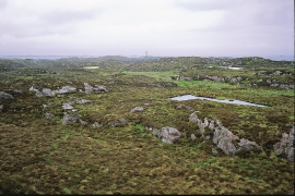
Fedje bog
The wild rabbit is really native to Northwest Africa, but the Ancient Romans introduced them to large parts of Europe. Not to Norway, rightly enough: the population on Fedje originated from 3-4 pairs that were brought here from the Shetland Isles in 1875, making this their first residence in the country.


Vinappen
Vinappen lies on a low hill to the very west on the island. Here you have an amazing panorama of the sea. Originally the area was grazing land for cattle, but this changed when the Germans occupied the island. Just before WWII there was a small bearing station, used by the Norwegian Coast Artillery in connection with exercises at sea.

Otterstad
Tthe Otterstad farms lie in the innermost part of Mofjorden, on the northwest side of the river. The row of stave-built boatsheds that belong to the farm were probably constructed a little after the middle of the 1800s. Both here and on the Mo side, the boatsheds were important storage places at the seashore; wood and other farm products intended for the town; corn and merchandise in return.

Otterstadstølen
Otterstadstølen lies in an idyllic grassy plain surrounded by rich forest, but also with high mountains close by. The mountainsides are steep and typical of this part of the county. The same cannot be said about the forest. This spruce forest has been able to develop freely for hundreds of years. Otherwise in the county, only Voss has spruce forest.

Stølsheimen
The large mountain area between Modalen, the Voss communities and Sogn is one of the finest mountain pasture areas in West Norway. In older times this area was called Steinslandsheimen, in our times it has acquired the name Stølsheimen. Power development and protection interests have been opposed here. The core area of Stølsheimen has now been protected as a landscape protection area, while some of the oldest mountain farms have been flooded. A register in the 1970s comprised almost 40 mountain farm settlements in the central area of Stølsheimen, belonging to Modalen, Høyanger and Vik municipalities.


Skogafjellet
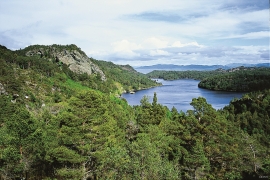
You have to travel to Scotland in order to find pine forests similar to those at Bømlo. The nearness to the sea has contributed in different ways to shaping one of the westernmost pine forests in Norway.


