- Remove Small landforms filter Small landforms
- Remove Øygarden, frå 2020 del av nye Øygarden kommune. filter Øygarden, frå 2020 del av nye Øygarden kommune.
- Remove Maritime environments filter Maritime environments
- Remove Seabirds filter Seabirds
- Remove Monastery filter Monastery
- Remove Fitjar filter Fitjar
- Remove Avalanches and rock falls filter Avalanches and rock falls
- Remove Masfjorden filter Masfjorden
- Remove Large landforms filter Large landforms
- Remove Bronze age filter Bronze age
- Remove Museum filter Museum

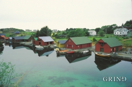
Hjelmo
On the farm Hjelmo, furthest north in Øygarden, in the innermost part of a long bay, there is a fine boatshed collection with a church beside it. From times immemorial this has probably been the fish-shed location for these farm units and this was also the landing place for the churchgoers.

Rimsvarden
Rimsvarden lies high and unencumbered, an enormous stone mound on the highest top with a wide view of the Fitjar rural community. With its 30 meters across and almost 4 meters high, this is one of the largest prehistoric burial relics existing in Hordaland.

Årskog
Årskog farm is situated in a typical coastal landscape in a gentle terrain that slopes down from the outlying heaths down towards the fjord. The farm steading exists as it was in the 1800s. In 1980 the two brothers, Lars and Olai Årskog donated the farm with all its contents of tools and interior decoration, for museum purposes.
Herdlevær
Herdlevær lies on one of the small islands west of Hjeltefjorden, facing the North Sea and the big ocean. Today you may arrive there by car. The numerous islands are linked together by elegant bridge spans made of concrete. Fifty years ago it was half a day’s journey to get to Herdlevær from the mainland by your own rowing boat or ferry.


Skogsøyna
There isn't much forest on Skogsøyna today, but that there is, has been planted. There is not much wildlife, either. But, quite a lot of birds pass by Skogsøyna during migration time. Ther is no other place along the coast where you can better observe the seabird migrations.

Dyrdal
If you journey along Austfjorden, you at the same time turn the pages of time back through Ice Age history. The landforms show how the landscape has developed gradually as the glaciers have grown - and melted again - in several episodes: from small cirques, we see innermost at Dyrdal, to larger fjords, like at Mas fjord further out.

Raunøya
The sea birds discovered it long ago. Raunøya and the surrounding islands are the most beautiful places in Masfjorden.


Fitjarøyane
If we study the group of islands south of Selbjørns Fjord from the air or on a sea map, we will notice that many of the islands are elongated and lie systematically in rows. The islands are divided by long sounds, for example Trollosen, Nuleia and Hjelmosen, which are oriented in a south-southeast to north-northwesterly direction.

