- Remove Modalen filter Modalen
- Remove Austrheim filter Austrheim
- Remove Samnanger filter Samnanger
- Remove Bømlo filter Bømlo
- Remove Vernacular crafts filter Vernacular crafts
- Remove Lakes, rivers and river networks filter Lakes, rivers and river networks
- Remove Conservation area filter Conservation area

Fossen Bratte
The steep drop by Fossen cliff has been the biggest challenge for those who wished to make a road over Kvamskogen through the years. Leave the car by the monument on the old road and take a walk down to the bend by the waterfall that Bergen-folk call "The bridal veil". Why is there a waterfall just here?

Frøland
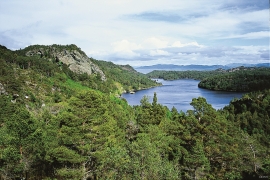
Much rain, a steep drop and nearness to Bergen meant that the power-making potential of the Samnanger water system was exploited early. Samnanger was thus one of the first power-producing municipalities in western Norway. With its subsequent expansion and new power stations, about 400 gigawatts of electricity per hour were produced on average each year. This is enough to meet the energy needs of 25,000 households.

Lona
One does not need much imaginationto see that where the river bends down in Røssebotnen, there has once been a lake. The landscape tells this - more clearly than any book.

Otterstadstølen
Otterstadstølen lies in an idyllic grassy plain surrounded by rich forest, but also with high mountains close by. The mountainsides are steep and typical of this part of the county. The same cannot be said about the forest. This spruce forest has been able to develop freely for hundreds of years. Otherwise in the county, only Voss has spruce forest.
Skogafjellet
You have to travel to Scotland in order to find pine forests similar to those at Bømlo. The nearness to the sea has contributed in different ways to shaping one of the westernmost pine forests in Norway.

Stølsheimen
The large mountain area between Modalen, the Voss communities and Sogn is one of the finest mountain pasture areas in West Norway. In older times this area was called Steinslandsheimen, in our times it has acquired the name Stølsheimen. Power development and protection interests have been opposed here. The core area of Stølsheimen has now been protected as a landscape protection area, while some of the oldest mountain farms have been flooded. A register in the 1970s comprised almost 40 mountain farm settlements in the central area of Stølsheimen, belonging to Modalen, Høyanger and Vik municipalities.


