- Remove Samnanger filter Samnanger
- Remove Voss, frå 2020 del av nye Voss herad. filter Voss, frå 2020 del av nye Voss herad.
- Remove Small landforms filter Small landforms
- Remove Vegetation history filter Vegetation history
- Remove Quarns and mills filter Quarns and mills
- Remove Fitjar filter Fitjar
- Remove Odda, frå 2020 del av nye Ullensvang kommune. filter Odda, frå 2020 del av nye Ullensvang kommune.
- Remove Hill forts filter Hill forts

Fossen Bratte
The steep drop by Fossen cliff has been the biggest challenge for those who wished to make a road over Kvamskogen through the years. Leave the car by the monument on the old road and take a walk down to the bend by the waterfall that Bergen-folk call "The bridal veil". Why is there a waterfall just here?


Grønafjellet
Mountain plants with their beautiful, colourful flowers are common in high altitude areas in Norway. On the coast there are not so many of them. But, here and there one nonetheless finds mountain plants, and this makes some coastal mountainsides a little bit different. Perhaps the growth on these mountainsides gives us a little glimpse of a distant past?

Bordalsgjelet
Deep down between the stone polished phyllite bedrock in Bordalsgjelet canyon, there is a cascading river. In close cooperation with hard polishing stones, the water has carved into the bedrock for thousands of years - and is still doing so today.

Rekvemylna
If you enter the farmyard at Rekve, some kilometres from Bulken, where the road departs to Giljarhus, you no longer meet “the miller”, Knut Hernes, in his old rural mill. But some years ago he would wish you welcome, friendly and hospitable, and show you around his mill, which had been his workplace for a generation. As light-footed as a youth he climbed in steep ladders high up into the waterfall, to let the water down on to the waterwheel.

Staup
The farm STAUP lies on a shelf in the terrain above Løno. From the highway E16 it is possible to glimpse the houses through the trees. The farm is without a road, and the old farmyard and the cultural landscape is very well preserved. In the 1980s grants were given to carry out maintenance work with the intention of protecting the houses in the farmyard.

Valldalen
Valldalen or Valdalen, the name that the locals used in past times, had been a permanent settlement for a long time, and later the biggest mountain-farm valley in western Norway. Since that time there have been many changes: Most of the fields are no longer in use. Bjørkeskogen, a birch forest that had grown in the valley for thousands of years, took more and more over. And in the valley bottom, the Valldals dam now keeps the artificially large Valldalsvatnet Lake in place.
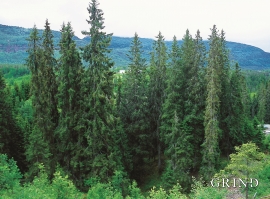
Vossagran
How did the spruce tree get to Voss? Did the seed or small spruce plants get help from people, for example, to make it here unscathed? Nobody knows.

