- Remove Sunnhordland filter Sunnhordland
- Remove Chieftains and royal lines filter Chieftains and royal lines
- Remove Civil servant dwellings and manors filter Civil servant dwellings and manors
- Remove Igneous rocks filter Igneous rocks
- Remove Churches filter Churches
- Remove Wetland filter Wetland

Støle
High above the sea and the beach flats, on one of the wide terraces shaped by the sea and the ice, lies the farm Støle (Stødle). The Old Norse name of Studla is derived from studill “support, shelf”. As far back as Viking times Støle has been a chieftain’s farm, a good farm on the plains formed by the moraine masses.


Vernøya
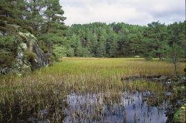
If you smell a foul smell out in nature, you mustn't immediately think that the reason is cloaca from houses or cabins. The reason can be an entirely natural process that occurs when plants are broken down under special conditions. When there is little oxygen available, hydrogen sulphide can be produced. This is a gas that seeps up from the earth and smells like rotten eggs.


Espevik
220 million years ago, glowing hot molten rock masses intruded into fractures in the earth's crust in the outer parts of Hordaland. Some of these are believed to have reached the surface and formed lava flows, which since have been eroded away by wind and weather. But, most of these flows solidified into diabase sills before they got to the surface.

Rimbareid- Vestbøstad
At nesting time you cannot avoid hearing the calls of the curlew or the snipe along the narrow road through the cultural landscape from Rimbareid to Vestbøstad. And on late summer evenings, the intense song of the sedge warbler rings out over the two characteristic tarns in the area.

Fitjarøyane
If we study the group of islands south of Selbjørns Fjord from the air or on a sea map, we will notice that many of the islands are elongated and lie systematically in rows. The islands are divided by long sounds, for example Trollosen, Nuleia and Hjelmosen, which are oriented in a south-southeast to north-northwesterly direction.

