- Remove Middle age filter Middle age
- Remove Nordhordland filter Nordhordland
- Remove Farm sites filter Farm sites
- Remove Trading posts and guesthouses filter Trading posts and guesthouses
- Remove Radøy, frå 2020 del av nye Alver kommune. filter Radøy, frå 2020 del av nye Alver kommune.
- Remove Lindås, frå 2020 del av nye Alver kommune. filter Lindås, frå 2020 del av nye Alver kommune.
- Remove Thrust sheets filter Thrust sheets


Lurekalven
Lurekalven is an unpopulated island of heather moor which is a part of the wilderness belonging to the five farms on Ytre Lygra. Between the two islands there is only a small sound. As late as the 1920s, milking cows were rowed over the sound from Lygra in summer – a form of farming that was adapted to the coastal landscape.

Vågenes
On Vågenes, on one of the prominences out toward Eitrevågen, one finds garnets in anorthosite. The garnets are both older, and not least bigger, than average.

Manger
Mangerite is a rock type that was first made famous in a treatise by the Bergen geologist Carl Fredrik Kolderup in 1903. The rock type got its name from the place where it was found, and has made the Mangerud name well known around the world, at least among geologists.
Isdal
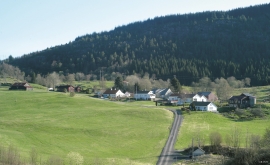
Isdal one of the few clustered settlements left in the Hordaland communities, after the extensive changes taking place around the turn of the former century, which broke up the shared farms and the old intermixture of strips. The old, low houses are situated in a compact enclosure, which is very noticeable in the landscape when you travel the main road north from Knarrvik.
Øvre Tveiten
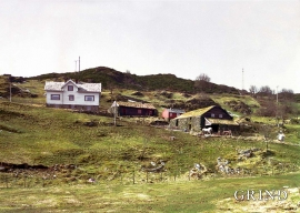
On an east-facing slope above Halllandsvatnet lies the farm hamlet of Øvre Tveiten, two kilometres north of Manger. The stone hayshed lies with its gable out into the sloping terrain, and the old dwelling house, a little long house, has solid stone walls on three sides. But inside the walls the hayshed and the living rooms are wooden buildings.

