- Remove Quarns and mills filter Quarns and mills
- Remove Coniferous forests filter Coniferous forests
- Remove Faults filter Faults
- Remove Mountain plants filter Mountain plants
- Remove Defense filter Defense
- Remove Lakes, rivers and river networks filter Lakes, rivers and river networks
Rådalen
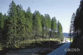
"...it would not be of any particular economical interest to support the planting of forest as the forest that can be cultivated will leave much to be desired in the way of growth potential." These words stem from the economist that at the end of the 1800s was sent to Stend to inspect the planned reforestation in person. The pioneer G.A.Wilson put the economist's words to shame. The spruce that was planted in Rådalen in the period 1867–1869 became a landmark. No other stand of forest in Scandinavia can boast more trees per unit area.

Mosnes
The permanently-protected Mosneselva River, with its meltwater from Folgefonna, runs out into Åkra Fjord by the roadless and uninhabited Mosnes. Those who once lived here were forced to surrender to the ravages of Nature. In the autumn of 1962 there was a flood so great that the people were driven from their farms.


Ekso
In the late 1800s, Ekso was known among the nobility in England as having among the best salmon rivers. In summer the Lords could haul in big fish of up to 25 kg. In return, the townsfolk were paid for fishing rights, lodging and local assistance.

Lona
One does not need much imaginationto see that where the river bends down in Røssebotnen, there has once been a lake. The landscape tells this - more clearly than any book.

Bjellandsvatnet
Lake Bjellandsvatnet is one of the richest wetland areas in Sveio. But, everything has its limit, and the supply of nutrients can be too much. This is what was about to happen in Lake Bjellandsvatnet.
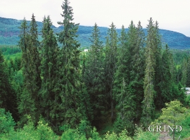
Vossagran
How did the spruce tree get to Voss? Did the seed or small spruce plants get help from people, for example, to make it here unscathed? Nobody knows.


Frøyset river network
Frøyset river network is protected from power station-building - not because of its pristine nature - but because it is a typical river network for this part of western Norway.

