- Remove Basement rocks filter Basement rocks
- Remove Midthordland filter Midthordland
- Remove Archaeological findings filter Archaeological findings
- Remove Late glacial filter Late glacial
- Remove Benthic organisms filter Benthic organisms
- Remove Metamorphic rocks filter Metamorphic rocks
- Remove Lakes, rivers and river networks filter Lakes, rivers and river networks

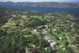
Vinnesleira
Bays that are shallow far out into the sea, with fine sand and clay, are rare in Hordaland. Where they are found, the reason is usually that the edge of the glacier made smaller advances or stopovers when it calved back at the end of the last Ice Age. This is what happened at Vinnesleira.
Ask- jordbær
Strawberry-growing on Askøy flourished in the beginning of the last century. When gardener Samson Eik took in the type "Seierherren" from Rosendal in 1909 for growing strawberries on Hop, it appeared that the soil and climate in this area was perfect for the mass production of strawberries.


Herdla – glacial deposits
The shift in the landscape is striking between the barren craggy moors north on Askøy and the green fields of Herdla, which has the county's biggest farm. The majority of Herdla, such as the island appears today, is a gift from the glacier: The glacier that advanced here over 12,000 years ago stopped at the northern tip of Askøy and took its time building up the moraine on Herdla. Since then, Herdla has been under continual transformation. The re-organisation of the loose sediment deposits continues today.

Fjell river network
There are many river networks out by the coast and they tend to be small and unassuming. The farmer has relied upon the watercourses to run his mill and saw, and it may be that the trout have given him a good source of food in years when the ocean fish failed. In our time, these river networks are being rediscovered for their value in recreation and outdoor life, and several places, tourist trails have been built in order to fully enjoy them.

Haganes
The gneiss landscape west and north of Bergen viewed in profile can remind us of a saw blade of the kind that has long, slanted sides that get broken off shorter transverse sides. It has taken several hundred million years to file this saw blade, an enduring interplay between various geological processes.

Høybøen
In connection with the planned developments in the oil sector at Vindenes around 1980, excavations were carried out under the auspices of Bergen Historical Museum. Exceptionally interesting traces of an old farm at Høybøen then came to light. These were the remnants of a farm where there had been two houses containing several rooms.

Fossen Bratte
The steep drop by Fossen cliff has been the biggest challenge for those who wished to make a road over Kvamskogen through the years. Leave the car by the monument on the old road and take a walk down to the bend by the waterfall that Bergen-folk call "The bridal veil". Why is there a waterfall just here?

Frøland
Much rain, a steep drop and nearness to Bergen meant that the power-making potential of the Samnanger water system was exploited early. Samnanger was thus one of the first power-producing municipalities in western Norway. With its subsequent expansion and new power stations, about 400 gigawatts of electricity per hour were produced on average each year. This is enough to meet the energy needs of 25,000 households.


