- Remove Small landforms filter Small landforms
- Remove Tourism filter Tourism
- Remove Monastery filter Monastery
- Remove Boat- and shipyards filter Boat- and shipyards
- Remove Wetland filter Wetland
- Remove Large landforms filter Large landforms

Sagvåg
The pit saw on the property of the farm Valvatna, is the origin of the name Sagvåg. The sawmill is mentioned as early as 1564. The name of the place at that time was Fuglesalt, but soon there is only talk of Saugvog.

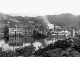
Sunde
In 1852 Haktor Thorsen erected two large warehouses on one of his farms in Sunde and started trading and salting herring. This was the start of an industrial adventure that made Sunde into one of the first industrial communities in Kvinnherad.

Halsnøy Monastery
Halsnøy Monastery is situated in the midst of the lush fjord country in Sunnhordland, on one of the old spits, or “necks”, that has given name to the island. Gently sloping fields lead down to the sea on both sides, in the south towards the Kloster Fjord, to the north towards the sheltered Klostervågen.


Granvinsvassdraget
After the ice age, Granvin Fjord reached all the way up under Skjervsfjossen waterfall. Just a thousand years later, as a result of the rising of the land after the ice melted, this whole inner part of the fjord freed itself of the sea and became Granvinsvatnet lake. In spite of this rise in elevation, this waterway is still navigable for fish: Sea trout have wandered into Granvinsvatnet in more recent times and evolved to become freshwater trout. And salmon and sea trout made the journey 13 kilometres up the Storelvi river.

Haugsdalen
Early in the 1900s there were much larger salt water deltas in Hordaland. But, essentially all of the larger river deltas got filled in and regulated for use in industry during the last century. Now, there is only Haugsdals delta left.

Ulvenvatnet
Lake Ulvenvatnet is thought to be the most species rich wetlands in the municipality. Despite this, the area is not protected, nor is it likely ever to be.

