- Remove Small landforms filter Small landforms
- Remove Large landforms filter Large landforms
- Remove Quarries filter Quarries
- Remove Road constructions filter Road constructions


Isdalen
The valley on the inside of the Svartediks dam, a five minutes' bus ride from Bergen centre, is often referred to by Bergen folk as Isdalen ("Ice Valley") - justifiably, since the area could have been described in textbooks for its ice-carved land forms. The glacier's polishing over ca. 40 ice ages has created a magnificient landscape. The original ice valley climbs up behind Ulriken at the end of Svartediket.

Sandviksfjellet
On Sandviksfjellet there are old boulders that have been made into mountains. The stones have been stretched out or squeezed together between huge slabs of rock, during slow, but powerfulprocesses of transport. This conglomerate shows, in quite a special way, the enormous powers that were active during the collision between Norway and Greenland over 400 million years ago.


Åsane
Most associate Åsane with ridges, naturally enough (the Norwegian word for "ridge" is "Ås"). A lesser noticed trait in the landscape are the unusual flat areas that lie between the ridges. The Dalselva River, which was channeled at the end of the 1950s, runs down only 2.5 metres from Lake Langavatnet by Vågsbotn to Flatevad, where it goes over into rapids by Fossekleiva. The layers of gneiss stand nearly vertically, and the mountain surface is so even that one might think it had been planed with a planer.

Dyrskard
Right from the start the road across Haukelifjell was a road from “fjord to fjord”, from the bottom of Sørfjorden to Dalen in Telemark. The connection between Røldal-Haukelifjell was considered so important by Stortinget (Parliament) that the road construction Odda-Dalen was approved already in 1853.

Reinsnos
The mountain settlement Reinsnos is situated at nearly 700 metres above sea level at the end of the Reinsnos lake; an entry point to the Hardanger plateau.

Stalheimskleiva
From the oldest times on record in Norway one of the most important traffic arteries between west and east Norway has passed across Bolstad – Voss – Stalheim – Gudvangen and Lærdal. The post road between Oslo and Bergen was established here 1647, but in Stalheimskleiva there was only a packhorse track right up to the 1840s. Wheeled transport and carts were in little use in the mountains in West Norway up to that time.
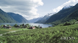
Måge
Steatite is a type of stone that is abundant in Hardanger. There are large steatite deposits in the mountain below Folgefonna. These deposits are visible both in Krossdalen in Jondal, at Kveitno in Odda and at Måge in Ullensvang. There are many traces of steatite quarrying in Hardanger, and one of the largest fields is in the hillside above Måge.

