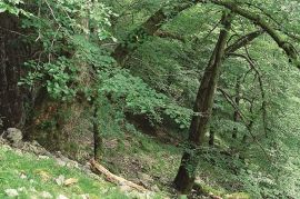
![Elm - and lime tree](https://www.grind.no/sites/default/files/styles/medium/public/bilder/sted/232/mas_16.jpg?itok=QbVLmuCx)
![Barn with stone end wall](https://www.grind.no/sites/default/files/styles/medium/public/bilder/sted/232/kvh_321-5.jpg?itok=3i5jhWB2)
![Cirque in Dyrdal in Lindås](https://www.grind.no/sites/default/files/styles/medium/public/bilder/sted/232/mas_22.jpg?itok=YmoL_BEr)
Dyrdal
If you journey along Austfjorden, you at the same time turn the pages of time back through Ice Age history. The landforms show how the landscape has developed gradually as the glaciers have grown - and melted again - in several episodes: from small cirques, we see innermost at Dyrdal, to larger fjords, like at Mas fjord further out.
![Portion of the Frøysetelva River, by Sleire.](https://www.grind.no/sites/default/files/styles/medium/public/bilder/sted/232/mas_1.jpg?itok=9nmGqHUe)
Frøyset river network
Frøyset river network is protected from power station-building - not because of its pristine nature - but because it is a typical river network for this part of western Norway.
![From Osterøy museum](https://www.grind.no/sites/default/files/styles/medium/public/bilder/sted/190/kvh_326_osteroy_museum_2_150.jpg?itok=tYZy_lqH)
![Godske and godske farm](https://www.grind.no/sites/default/files/styles/medium/public/bilder/sted/232/ost_14.jpg?itok=LtA2mg0y)
![Hamre church, Osterøy](https://www.grind.no/sites/default/files/styles/medium/public/bilder/sted/232/kvh_325-2_-hamre_kirke.jpg?itok=vm3U9puE)
Hamre Church
Hamre Church has, by all accounts been one of the four main churches in Horda County in the Middle Ages. Hamre was a main church for the whole of Hordaland. Timber remains in the present church show that there was a stave church here in medieval times.
![The Haugsdal delta](https://www.grind.no/sites/default/files/styles/medium/public/bilder/sted/232/mas_4.jpg?itok=70eU9NoY)
Haugsdalen
Early in the 1900s there were much larger salt water deltas in Hordaland. But, essentially all of the larger river deltas got filled in and regulated for use in industry during the last century. Now, there is only Haugsdals delta left.
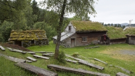
![Havrå and the arable fields up to the enclosed meadow.](https://www.grind.no/sites/default/files/styles/medium/public/bilder/sted/1/kvh_323-1_-havraatunet.jpg?itok=fiE6Ax_w)
Havrå
In the sunny, steep fjord landscape along Sørfjorden on the east side of Osterøy is the farm Havrå. The small “hamlet” is one of the few undisturbed farming communities that gives us the impression of the large communal yards in West Norway in the 1700s, with houses built close together and strips of arable land.
![The power station at Herlandsfossen, Osterøy](https://www.grind.no/sites/default/files/styles/medium/public/bilder/sted/232/kvh_327-4.jpg?itok=UYh1p6Mj)