- Remove Standard side filter Standard side
- Remove Monastery filter Monastery
- Remove Civil servant dwellings and manors filter Civil servant dwellings and manors
- Remove Place filter Place
- Remove Hardanger og Voss filter Hardanger og Voss
- Remove Sunnhordland filter Sunnhordland
- Remove Large landforms filter Large landforms


Bondhusdalen
The Bondhus area in Maruanger has been a magnet for tourists ever since the stream of tourists to Norway's west coast began in the middle of the 1800s. The magnificent landscape with the "ice trail" up to Bondhusvatnet Lake, the ice falls from Bondhusbreen glacier and Keisarstigen trail up to Folgefonna are still popular tourist attractions.


Einstapevoll- the farm
Einstapevoll (from einstape: “bregne” (fern)) lies on the west side of the Tittelsnes peninsula. Up to 1831 the farm was a vicarage belonging to Stord parish. The priests had leasing rights. Land rent and other fees from the farm was part of their salaries.


Fitjarøyane
If we study the group of islands south of Selbjørns Fjord from the air or on a sea map, we will notice that many of the islands are elongated and lie systematically in rows. The islands are divided by long sounds, for example Trollosen, Nuleia and Hjelmosen, which are oriented in a south-southeast to north-northwesterly direction.

Halsnøy Monastery
Halsnøy Monastery is situated in the midst of the lush fjord country in Sunnhordland, on one of the old spits, or “necks”, that has given name to the island. Gently sloping fields lead down to the sea on both sides, in the south towards the Kloster Fjord, to the north towards the sheltered Klostervågen.
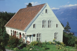
Helleland
The old “recorder residence” at Helleland has been both residence for the district recorder and officer’s residence. The main building, which came under protection in 1924, was built in 1764 by the curate Christian Heiberg. When he was appointed parish priest in Jølster, he sold the farm to the state employee Geelmuyden, who resold the farm to Hans De Knagenhielm in 1774. He was the head of “Søndre Hardangerske kompani” (a local army division).
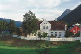
Hesthamar
Hesthamar, some kilometres north of Utne, is one of the oldest residences for a district recorder in the country. In 1637, barely 50 years after the office of the district recorder was established in 1591, the local people bought this residence from the bailiff Lauritz Johnsen on Torsnes. From 1659 the district recorders lived here, intermittently, up to 1790. This is when Helleland at Lofthus became a “recorder” farm.

