- Remove Place filter Place
- Remove Churches filter Churches
- Remove Voss, frå 2020 del av nye Voss herad. filter Voss, frå 2020 del av nye Voss herad.
- Remove Vernacular crafts filter Vernacular crafts
- Remove Lakes, rivers and river networks filter Lakes, rivers and river networks
- Remove Tourism filter Tourism


Evanger
Evanger (from Old Norse ålvangr, “vang”, “voll” (field) where the horses may graze) is the place where the river from Vangsvatnet, the Voss watercourse, runs out into Evangervatnet. From here Teigdalen valley runs to the north, towards Eksingedalen, and from here there is a short distance to Bergsdalen in the south.


Stalheim
Stalheim is situated between Stalheimsfossen and Sivlefossen, in a community with the farms Sivle and Brekke. The most likely explanation of the name is “the farm by Stadall”, from “standa” (stand), probably with background in the steep Stalheimskleivi. The farm has for a long time been divided into several units. At Stalheim there has been a transport exchange from the Middle Ages and the farm has been a postal farm since 1647.
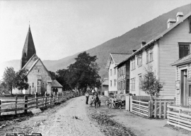
Vangskyrkja
Vangskyrkja (Vangen church) is the largest of the medieval churches in Hordaland; one of the four “fjordung” churches in the county. A royal letter from 1271 shows that the church was under construction at this time. Vossevangen at Vangsvatnet, where the wide and expansive valleys of the Voss communities meet, was the natural location for a church.


The Vosso river network
The Vosso is Hordaland's main artery, she has never run more richly than in our times, and no other river in western Norway carries so much water. The increase in the amount of water comes mainly from hydropower development, due to the transfer of water from other water systems. Climate change can also be a reason that the Vosso carries more water than before.
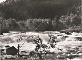
Vosso
There is probably no bigger salmon to be found in the whole wide world than in Vosso. The average size varies from season to season of course, but for many years this fish has had an average weight of over 10 kilograms. Thumping big ones of 30 kg. have been fished from the river, but one must go back to the 1940s for the last salmon of this size last that was caught.

