- Remove Cultural landscapes filter Cultural landscapes
- Remove Samnanger filter Samnanger
- Remove Voss, frå 2020 del av nye Voss herad. filter Voss, frå 2020 del av nye Voss herad.
- Remove Archaeological findings filter Archaeological findings
- Remove Literature filter Literature
- Remove Hydro power filter Hydro power
- Remove Vegetation history filter Vegetation history
- Remove Lindås, frå 2020 del av nye Alver kommune. filter Lindås, frå 2020 del av nye Alver kommune.

Frøland
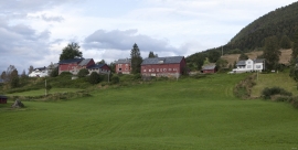
Much rain, a steep drop and nearness to Bergen meant that the power-making potential of the Samnanger water system was exploited early. Samnanger was thus one of the first power-producing municipalities in western Norway. With its subsequent expansion and new power stations, about 400 gigawatts of electricity per hour were produced on average each year. This is enough to meet the energy needs of 25,000 households.


Lurekalven
Lurekalven is an unpopulated island of heather moor which is a part of the wilderness belonging to the five farms on Ytre Lygra. Between the two islands there is only a small sound. As late as the 1920s, milking cows were rowed over the sound from Lygra in summer – a form of farming that was adapted to the coastal landscape.

Lygra
The heath landscape on outer Lygra, Utluro and Lurekalven will in future become part of a landscape protection area, to be maintained through traditional activities with year-round outdoor sheep, grazing and burning. The West Norwegian heath country belongs to a large North Atlantic coastal landscape stretching from the Bay of Biscay to the Lofoten islands.


Vollom
On Vollom, northwest of Seim, we find the only natural beech forest in Western Norway, which is also the most northerly of its type in the world. Beech grows also many other places in the county, but these trees are totally lacking in history compared with those of Vollomskogen Forest.

Byrkjehaugen
On the farm Bø, close to the highway between Bulken and Voss lies Byrkjehaugen, one of the largest burial mounds in West Norway. Originally it was around 50m across and 5m high, but following the excavation in 1908 and chipping off by both railway and road construction, the cross-section has shrunk to 37m and the height to 4m. All the same, it is an impressive burial monument for the passing traveller to see.