- Remove Cultural landscapes filter Cultural landscapes
- Remove Samnanger filter Samnanger
- Remove Voss, frå 2020 del av nye Voss herad. filter Voss, frå 2020 del av nye Voss herad.
- Remove Archaeological findings filter Archaeological findings
- Remove Literature filter Literature
- Remove Sveio filter Sveio
- Remove Waterfalls filter Waterfalls
- Remove Churches filter Churches
- Remove Lighthouses filter Lighthouses

Fossen Bratte
The steep drop by Fossen cliff has been the biggest challenge for those who wished to make a road over Kvamskogen through the years. Leave the car by the monument on the old road and take a walk down to the bend by the waterfall that Bergen-folk call "The bridal veil". Why is there a waterfall just here?


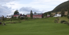
Ådland
Ådland, innermost in the Samnanger Fjord is an old church centre and transport centre; a nodal point in the transport from sea to land. The white painted church standing today, was built in 1851, but there were two older churches here in former centuries.
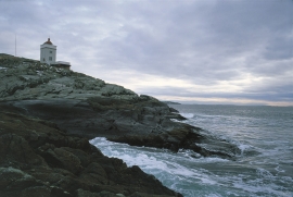
Ryvarden
In the Islandic Landnåmabok there is a story that the explorer Floke Vilgjerdsson built a cairn “where meetest Hordaland and Rogaland” and the cairn was named Flokavarði. Tormod Torfæus wrote in Historia Norvegica (1711) that this name was still in use, but that the farmers used “Ryvarden” for the same place.


Byrkjehaugen
On the farm Bø, close to the highway between Bulken and Voss lies Byrkjehaugen, one of the largest burial mounds in West Norway. Originally it was around 50m across and 5m high, but following the excavation in 1908 and chipping off by both railway and road construction, the cross-section has shrunk to 37m and the height to 4m. All the same, it is an impressive burial monument for the passing traveller to see.

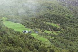
Ulvund
One of the oldest farms in Myrkdalen, Ulvund, is recognized as one of 14 areas in Hordaland having an especially valuable cultural landscape. The dirt road runs along a steep slope down toward Lake Myrkdalsvatnet. The flattest field, which today is harvested for silage, used to be an old grain field, while the slopes were old hayfields.

