- Remove Cultural landscapes filter Cultural landscapes
- Remove Samnanger filter Samnanger
- Remove Voss, frå 2020 del av nye Voss herad. filter Voss, frå 2020 del av nye Voss herad.
- Remove Large landforms filter Large landforms
- Remove Vegetation history filter Vegetation history
- Remove Fusa, frå 2020 ein del av nye Bjørnafjorden kommune filter Fusa, frå 2020 ein del av nye Bjørnafjorden kommune
- Remove Stone age filter Stone age
- Remove Conservation area filter Conservation area


Holmefjord
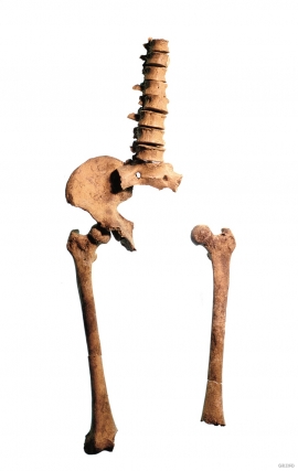
Even though we know of several hundred burial places from the Stone Age in Hordaland, we do not often hit on the Stone Age Man himself. But there are a few.
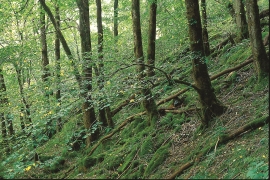
Hopslia
Some of the giant trees in Hopslia north of Holme Fjord are as much as thirty metres high. Elm and ash are the most common, basswood somewhat rarer. Relatively soft bedrock, good growing conditions and enough light, help them to thrive just here.

Yddal
Yddal is one of the biggest and finest pine forest areas in the county. The rich forest resources provided an important foundation for the settlement of Yddal. Up until about the 1950s, there were three farms here. Where the lumberjacks couldn't get to, the trees grew very big and can be over 300 years old.

Vinnesleira
Bays that are shallow far out into the sea, with fine sand and clay, are rare in Hordaland. Where they are found, the reason is usually that the edge of the glacier made smaller advances or stopovers when it calved back at the end of the last Ice Age. This is what happened at Vinnesleira.


Hamlagrø
The type of underlying rock can be decisive for how many different types of plants are found in an area. In the area around Hamlagrø-lake the diversity is especially obvious. The geological conditions change much here within a short distance.

Lønaøyane
The Strandaelvi river is forever protected from the development of hydropower. The Lønaøyane islands – which comprise the delta furthest north in Lake Lønavatnet - are a part of this water system. In 1995 the level of protection for the Lønaøyne islands was strengthened to that of a nature preserve because of the rich birdlife in this wetland.

