- Remove Cultural landscapes filter Cultural landscapes
- Remove Samnanger filter Samnanger
- Remove Voss, frå 2020 del av nye Voss herad. filter Voss, frå 2020 del av nye Voss herad.
- Remove Small landforms filter Small landforms
- Remove Vegetation history filter Vegetation history
- Remove Vernacular arts filter Vernacular arts
- Remove Trading posts and guesthouses filter Trading posts and guesthouses
- Remove Lakes, rivers and river networks filter Lakes, rivers and river networks
- Remove Austevoll filter Austevoll
- Remove Seabirds filter Seabirds
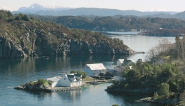
Bakholmen
On Austre Bakholmen, a small islet of around 15 acres between Hundvåko and Drøni, lies the oldest trading centres in Austevoll. For a long time this was a court location and it was a natural centre in this archipelago.

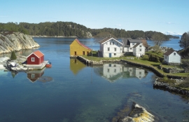
Krosshamn
Krosshamn lies in the shipping lane northeast of Hundvåkøy, near Sandtorv. The name probably derives from the fact that this is Austevoll’s harbour situated nearest to Korsfjorden.
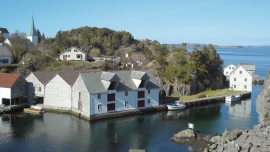
Kvalvåg
Kvalvåg on Stolmen is first mentioned as a trading post in 1655, and in 1731 the owner Jens Meyer, was granted a royal trading privilege.


Fossen Bratte
The steep drop by Fossen cliff has been the biggest challenge for those who wished to make a road over Kvamskogen through the years. Leave the car by the monument on the old road and take a walk down to the bend by the waterfall that Bergen-folk call "The bridal veil". Why is there a waterfall just here?

Frøland
Much rain, a steep drop and nearness to Bergen meant that the power-making potential of the Samnanger water system was exploited early. Samnanger was thus one of the first power-producing municipalities in western Norway. With its subsequent expansion and new power stations, about 400 gigawatts of electricity per hour were produced on average each year. This is enough to meet the energy needs of 25,000 households.


