- Remove Cultural landscapes filter Cultural landscapes
- Remove Ulvik filter Ulvik
- Remove Voss, frå 2020 del av nye Voss herad. filter Voss, frå 2020 del av nye Voss herad.
- Remove Iron age filter Iron age
- Remove Coniferous forests filter Coniferous forests
- Remove Etne filter Etne

Borgåsen
In Etne there are no less than four defensive refuges. They are all situated in strategic positions, so that they have served as places of refuge and protection for central parts of the district

Byrkjehaugen
On the farm Bø, close to the highway between Bulken and Voss lies Byrkjehaugen, one of the largest burial mounds in West Norway. Originally it was around 50m across and 5m high, but following the excavation in 1908 and chipping off by both railway and road construction, the cross-section has shrunk to 37m and the height to 4m. All the same, it is an impressive burial monument for the passing traveller to see.


Holo
I Kvassdalen var det aktiv stølsdrift med mjølking av kyr og geitehald nokre år inn i vårt tusenår, og slik hadde det vore i meir enn to hundre år. Såleis har dalen ikkje fått gro til med kratt og skog, men er open og lys. Fortsett er det beiting av kyr og sauer.


Osa
At the bottom of the Osa fjord there is a cultural landscape marked by great contrasts; the wide terraces and the river delta at the fjord contrast with the steep hillsides in the background, where Norddalen leads up to the mountain. There are two farms here. Osa and Sævartveit – the farm at the river mouth and the hollow by the sea.


Stordalen
When the Etne water system was protected in 1994, preservation of the cultural landscape in Stordalen Valley was a a main objective. This is a valley with an exceptional abundance of Different types of plants and animals. In the grey alder forest in Stordalen there are more bird species than in most other places, in fact, denser than one tends to find in a tropical rainforest.

Ulvund
One of the oldest farms in Myrkdalen, Ulvund, is recognized as one of 14 areas in Hordaland having an especially valuable cultural landscape. The dirt road runs along a steep slope down toward Lake Myrkdalsvatnet. The flattest field, which today is harvested for silage, used to be an old grain field, while the slopes were old hayfields.
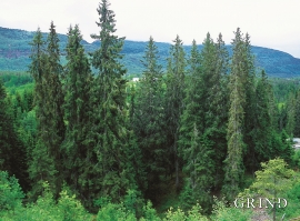
Vossagran
How did the spruce tree get to Voss? Did the seed or small spruce plants get help from people, for example, to make it here unscathed? Nobody knows.

