- Remove Middle age filter Middle age
- Remove Maritime environments filter Maritime environments
- Remove Civil servant dwellings and manors filter Civil servant dwellings and manors
- Remove Nordhordland filter Nordhordland
- Remove Quarries filter Quarries
- Remove Hardanger og Voss filter Hardanger og Voss
- Remove Chieftains and royal lines filter Chieftains and royal lines
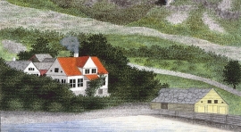
Helleland
The old “recorder residence” at Helleland has been both residence for the district recorder and officer’s residence. The main building, which came under protection in 1924, was built in 1764 by the curate Christian Heiberg. When he was appointed parish priest in Jølster, he sold the farm to the state employee Geelmuyden, who resold the farm to Hans De Knagenhielm in 1774. He was the head of “Søndre Hardangerske kompani” (a local army division).

Bru
Bruosen is one of the few river harbours in the county. As landing place for the churchgoers, this place and the boatshed environment follow a tradition that goes back to the Middle Ages, but the country store of today is much younger.

Håøy
Håøy lies centrally in one of the main shipping lanes going into Bergen --- with Håyøsund on the south side facing Meland, and Hagelsundet facing Lindåslandet. Names like Nordfarskista and Nordfarsskorane explain things. The strategic position was important in Viking times and it has been important in our days too. The beacon on Håøy can have been built in the establishment of the coastal administration in Håkon the Good’s time, about 950 AD. The defence structure of which we say remains on Håøy Summit held a critical position during Norwegian neutrality during the First World War. The defence structure was taken down in 1957.

Holmeknappen
If you come by sea to Bergen and come up the Herdle Fjord, the yellow ochre marine shed at Holmeknappen is a well known landmark to starboard as you come close to the little shore settlement. In olden days Holmenknappen served important functions as a centre for a wide hinterland of the surrounding farms, warehouse, landing point, country store and later a steamer quay, a hotel (1896) and a dairy (1909). But today Holmeknappen is no longer a focal point. Transport and commercial routes have changed the old pattern

Holmen
HOLMEN AND THE KØLLE FAMILY Holmen lies by the fjord, innermost in Ulvikpollen. Originally this was a small smallholding or coast dweller’s place belonging to the farm Håheim. Major Johan Henrik Palludan obtained leasehold for a part of Holmen in 1773, and erected a grand house, as he was the head of Nordre Hardangerske kompani. In 1806 Mrs Palludin sold Holmen to the somewhat eccentric theologian Kristian Kølle, and thus the Kølle family came to Ulvik. Today the Kølle house in Holmen is gone, today it is the residence of the principal of the State horticultural school that occupies the ground – a villa in the dragon style from the turn of the previous century.

Krossøy
Furthest north in the island community Rongevær, at the entrance to Fensfjorden, lies Krossøy. Belonging to the farm are the islands of Krossøy, Husøy, Kårøy, Lyngkjerringa, Søre Kjerringa, Rotøy and Kuhovet. All of them have been inhabited. On Krossøy itself today there are four holdings. The marine use environment here is one of the best preserved along the West Norwegian coast.

Seim
Sæheim (Seim) at Lygrefjord is mentioned as one of the royal farms of Harald Hårfagre. Several of the first Norwegian national kings had their seat here, and the farm became Crown Property up to the 1400s. According to the sagas, Håkon den gode is buried on the farm.

Øvre Folkedal
Folkedal, which today is like a small “detour” from the main highway, was in the Middle Ages centrally situated in one of the most important roads between Hardanger and Voss. This is the road that Olav Haraldsson travelled in 1023, when he came from the royal farm at Avaldsnes for a meeting with the Voss inhabitants about the new belief. The road passes across the mountain pasture Krossaset and down Bordalen to Vangen.

Matrehola
On a large gravel terrace in Matredalen (the Matre valley), a couple of kilometres from the coastal settlement Matre, lies Storseterhilleren, at the end of a large stone block that came rushing down from the mountain. The Matre river runs just over 100 metres to the east of the cave.

Otterstad
Tthe Otterstad farms lie in the innermost part of Mofjorden, on the northwest side of the river. The row of stave-built boatsheds that belong to the farm were probably constructed a little after the middle of the 1800s. Both here and on the Mo side, the boatsheds were important storage places at the seashore; wood and other farm products intended for the town; corn and merchandise in return.

