- Remove Middle age filter Middle age
- Remove Maritime environments filter Maritime environments
- Remove People and Society filter People and Society
- Remove Civil servant dwellings and manors filter Civil servant dwellings and manors
- Remove Churches filter Churches
- Remove Chieftains and royal lines filter Chieftains and royal lines
- Remove Settlements, Villages, Towns filter Settlements, Villages, Towns
- Remove Arkitektur filter Arkitektur
Helleland
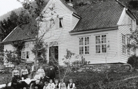
The old “recorder residence” at Helleland has been both residence for the district recorder and officer’s residence. The main building, which came under protection in 1924, was built in 1764 by the curate Christian Heiberg. When he was appointed parish priest in Jølster, he sold the farm to the state employee Geelmuyden, who resold the farm to Hans De Knagenhielm in 1774. He was the head of “Søndre Hardangerske kompani” (a local army division).

Bru
Bruosen is one of the few river harbours in the county. As landing place for the churchgoers, this place and the boatshed environment follow a tradition that goes back to the Middle Ages, but the country store of today is much younger.
Civil Servants in Small Societies 1650 – 1850

Einstapevoll- the farm
Einstapevoll (from einstape: “bregne” (fern)) lies on the west side of the Tittelsnes peninsula. Up to 1831 the farm was a vicarage belonging to Stord parish. The priests had leasing rights. Land rent and other fees from the farm was part of their salaries.
Sørhuglo
The tax collector’s farm at Sørhuglo is one of the many farms for state employees in Hordaland. According to history, “Futastovo” was built by the tax collector Gram in the second half of the 17th century. In 1943 the building was moved to Sunnhordland Folk Museum.
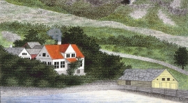
Ferstad
Ferstad is well worth a visit. The farm lies on a little hillock south of Lekven: a beautiful official residence from the 1700s.
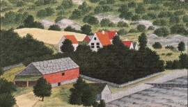
Engevik
Halfway into the Sævareidfjord lies the officer’s farm Engevik. In the beginning of the 1700s the farm was in part estate of the crown and owned by farmers. In 1724 lieutenant-colonel Christian Wilhelm Segelcke settled there and erected a new farm around an imposing main building a little way north of the old farm site.

Notaholmen
The fishnet shed at Notaholmen stands as a reminder of the days when people used to row out on the fjord to set their nets. On Notaholmen the nets were dried, repaired and tanned. And it was a great advantage to store them in a place inaccessible for rats and mice.

Bryggen
In the 1300s Bergen was a trading centre of European dimension. The town is thought to have had around 7000 inhabitants and was the largest and most important in the country. In a European context it was an average size town. At this time the most tightly built town area was still mostly east of Vågen from Holmen in the north to Vågsbotn in the south. Already in medieval times, latest in the 1340s, this area was called Bryggen.

Vågsbunnen
Vågsbotn was the name of the innermost part of the eastern part of town from Auta-almenning (today’s Vetrlidsalmenning), skirting the bottom of Vågen to Allehelgenskirken (All Saints’ Church) (at the present Allehelgensgate). In early medieval times Vågen reached almost all the way to Olavskirken (the Cathedral). It was a relatively wide bay inside the premonitory where Korskirken was built. The area was therefore much shorter than what is known as Vågsbunnen today.

