- Remove Middle age filter Middle age
- Remove Road constructions filter Road constructions
- Remove Nordhordland filter Nordhordland
- Remove Vernacular crafts filter Vernacular crafts
- Remove Large landforms filter Large landforms
- Remove Mines filter Mines
- Remove Railroad filter Railroad
Stormark
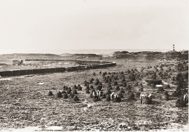
Both the climate and people have been decisive in shaping the bog landscape on Fedje - a landscape that has been evolving over several thousands of years. The peat got built up layer for layer and provided income and fuel for the people of Fedje.


Lurekalven
Lurekalven is an unpopulated island of heather moor which is a part of the wilderness belonging to the five farms on Ytre Lygra. Between the two islands there is only a small sound. As late as the 1920s, milking cows were rowed over the sound from Lygra in summer – a form of farming that was adapted to the coastal landscape.

Dyrdal
If you journey along Austfjorden, you at the same time turn the pages of time back through Ice Age history. The landforms show how the landscape has developed gradually as the glaciers have grown - and melted again - in several episodes: from small cirques, we see innermost at Dyrdal, to larger fjords, like at Mas fjord further out.


Eldsfjellet
The eclogites in western Norway were formed when Precambrian basement rocks were squeezed and pressed down under great pressure deep under the Caledonian mountain chain. The process may well have triggered some of the deepest earthquakes the world has ever known. The clearest traces of this drama are found in and around Mt. Eldsfjellet, in peaceful Meland.


Salhusfjorden
When the debate about building a pontoon bridge over Salhus Fjord was raging, some were afraid that the bridge would disrupt the ecology of the fjord system inside. The worst predictions did not prove true, but it is easy to see that there was a change: the Puffins have gotten a new food platter after the Nordhordaland bridge was built. Its favourite meal, mussels, thrive on the pontoons that are the foundation for the bridge.


