- Remove Maritime environments filter Maritime environments
- Remove Place filter Place
- Remove Trading posts and guesthouses filter Trading posts and guesthouses
- Remove Vaksdal filter Vaksdal
- Remove Modalen filter Modalen
- Remove Tysnes filter Tysnes
- Remove Arkitektur filter Arkitektur
- Remove Late glacial filter Late glacial
- Remove Askøy filter Askøy

Eksingedalen- landscape
Eksingedalen alternates between wide, flat flood plains with good farmland, and narrow passages with waterfalls where the roads cling to the mountainsides. The alternations in the landscape are a result of the sculpturing work by glaciers over several ice ages, and the deposition of the glacial river deposits when the last glacier finally melted back.

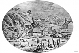
Godøysund
The old hostelry centres were strategically placed with good harbours and anchoring conditions where people travelled. GODØYSUND, or Gøysundet, as it was called, was in the middle of Tysnes Parish, with easy access from the sea, also for the local population. Gøysundet is amongst the oldest hostelries in Sunnhordland.

Herdla – glacial deposits
The shift in the landscape is striking between the barren craggy moors north on Askøy and the green fields of Herdla, which has the county's biggest farm. The majority of Herdla, such as the island appears today, is a gift from the glacier: The glacier that advanced here over 12,000 years ago stopped at the northern tip of Askøy and took its time building up the moraine on Herdla. Since then, Herdla has been under continual transformation. The re-organisation of the loose sediment deposits continues today.

Klinkholmen
Kubbervik, or Vikjo as it was known colloquially, must have been established as a trading post under the farm of Håland some time around 1600. The reason for this was probably the thriving trade on Scotland. Every year ships from the islands in the west came to buy lumber in Bårsund. Vikjo was the harbour in use, as the place is ideally situated on the route through Bårsund, the sound between Reksteren and Tysnesøy.

Mostraumen
Until 1743 the people from Modal had to wait for a flood in MOSTRAUMEN before they could draw their boats up the river current, and then row back across Lake Movatnet. But, that year the flood opened a free passageway all the way to Mo. Hordaland had gained a new tidal waterway.

Nedre Helland- Sand Quarries
The three spades in the municipal coat of arms for Modalen are sand spades. Sand quarrying has brought income and employment. As much as 70,000-80,0000 tonnes of sand and gravel left the municipality each year since the turn of the millennium, to be used as cementing sand. Why is Modalen endowed with so much sand?
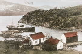
Neshamn
Neshamn must be an ancient place for meeting and spending the night for travellers. The place blossomed in connection with the times of economic expansion in the 1500s, which to a large extent was linked to the Scottish trade at this time. Neshamn was a loading place for Scottish ships for two hundred years, up to the middle of the 1700s.

Otterstad
Tthe Otterstad farms lie in the innermost part of Mofjorden, on the northwest side of the river. The row of stave-built boatsheds that belong to the farm were probably constructed a little after the middle of the 1800s. Both here and on the Mo side, the boatsheds were important storage places at the seashore; wood and other farm products intended for the town; corn and merchandise in return.

Strusshamn
On the south side of Askøy, just west of Bergen, lies Strusshamn. The sheltered bay is one of the best harbours in Byfjorden, on the route south. At the time of the sailing ships the harbour could be full of vessels from Bergen and abroad, lying in wait for favourable wind. Old anchoring rings from 1687 bear witness to this. Strusshamn was a quarantine harbour for ships that came sailing in with the yellow pest flag flying.

