- Remove Quarns and mills filter Quarns and mills
- Remove Farm sites filter Farm sites
- Remove Maritime environments filter Maritime environments
- Remove Sediments filter Sediments
- Remove Austevoll filter Austevoll
- Remove Ulvik filter Ulvik
- Remove Øygarden, frå 2020 del av nye Øygarden kommune. filter Øygarden, frå 2020 del av nye Øygarden kommune.


Frøystein
The farm Frøystein by the Ulvik fjord is commonly called Fryste. In 1614 the name was written Frøstemb – an obvious Danish influence – and the form Frøsten was used up until the land register in 1886 and 1907. It is probable that the name of the farm originally was Frystvin; a vin-name. Thus it has no connection with neither Frøy (Norse fertility god) nor stein (stone).
Herdlevær
Herdlevær lies on one of the small islands west of Hjeltefjorden, facing the North Sea and the big ocean. Today you may arrive there by car. The numerous islands are linked together by elegant bridge spans made of concrete. Fifty years ago it was half a day’s journey to get to Herdlevær from the mainland by your own rowing boat or ferry.

Hjelmo
On the farm Hjelmo, furthest north in Øygarden, in the innermost part of a long bay, there is a fine boatshed collection with a church beside it. From times immemorial this has probably been the fish-shed location for these farm units and this was also the landing place for the churchgoers.
Hufthammar
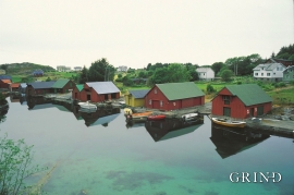
Farming in Austevoll has nearly all been in combination with fishing as the main industry. The farms in the district are therefore small, even in a west Norwegian context.

Kvernapollen
When the workers came to Kollsnes to start on the work with the landing for the gas terminal from the Troll field in the North Sea, they found the ruins of an old farm mill at Kvernapollen.

Rallarvegen
They rest there, all as one, the silent witnesses of Western Norway's saga of creation: Precambrian basement, phyllite and thrust sheet. In the end came the glaciers and sculptured the vast landscape. Along the ground or on the horizon, from bicycle or on foot - the landscape tells its story - and it tells it clearer on Rallarvegen than many other places.

Ulvik-village
The ice cap that covered the land during each of the 40 past ice ages over the past 2 million years of Earth's history pressed down the crust of the earth - like a finger on a rubber ball. And when the ice finally loosened its grip 11,000 years ago, the earth's crust rose again, most where the ice was thickest, least where it was thin, quickly in the beginning, and later more slowly. To this day, the land in the inner part of Norway continues to rise by perhaps one millimetre per year. By and large, however, the crust in Hordaland has again reached equilibrium after the weight of the ice was removed.

