- Remove Quarns and mills filter Quarns and mills
- Remove Music filter Music
- Remove Maritime environments filter Maritime environments
- Remove Chieftains and royal lines filter Chieftains and royal lines
- Remove Trading posts and guesthouses filter Trading posts and guesthouses
- Remove Quarries filter Quarries
- Remove Os, frå 2020 del av nye Bjørnafjorden kommune filter Os, frå 2020 del av nye Bjørnafjorden kommune
- Remove Bømlo filter Bømlo

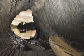
Espevær- the Trading Post
In the sea west of Bømlo lies Espevær, half an hour’s rowing trip across the sound from Vespestadvågen. This is a well-run and well-maintained local community, established on the back of the rich herring fisheries in the 1850s. It is fishermen, skippers and the tradesmen who have made their mark on the culture in Espevær, with their contacts to the south towards Haugesund and across the North Sea to the British Isles.


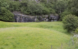

Siggjo
Siggjo is a cone-shaped, volcano-like mountaintop in the part of Hordaland where one finds the best preserved volcanic rocks. The rock types originate from one or several volcanoes that spewed out glowing lava and ash. But, the shape of the mountain, as it appears today, formed later and by completely different forces.

Urangsvågen-Rubbestadneset
In 1868 the first stone workers came to Rubbestadneset to take out the granite for the Skoltegrunns Pier, predecessor of the Skoltegrunns wharf in Bergen. Later granite was also taken out from the area, around Innværs Fjord and UransvågenN. The activity probably peaked around 1900, with over 40 men at work. 15 years later, it was finished.

Grødalshaug
At the bottom of Vargavågen on Halhjem lies Grødalshaug, a 30 metres high rocky outcrop between the bay and a moist valley cleft. On the south side of the rock is a steep rock cliff facing the valley, the bog and the stream. On this rock face we find rock carvings from the Bronze Age.