- Remove Quarns and mills filter Quarns and mills
- Remove Mineral resources filter Mineral resources
- Remove Railroad filter Railroad
- Remove Large landforms filter Large landforms
- Remove Midthordland filter Midthordland


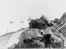
Sandviken
Close to the tunnel opening at Amalie Skrams vei in Ssandviken, there is a cultural monument of European dimensions; a rope making works that produced rope and fishing tackle for West and North Norway.


Åsane
Most associate Åsane with ridges, naturally enough (the Norwegian word for "ridge" is "Ås"). A lesser noticed trait in the landscape are the unusual flat areas that lie between the ridges. The Dalselva River, which was channeled at the end of the 1950s, runs down only 2.5 metres from Lake Langavatnet by Vågsbotn to Flatevad, where it goes over into rapids by Fossekleiva. The layers of gneiss stand nearly vertically, and the mountain surface is so even that one might think it had been planed with a planer.

Ågotnes- crystals
Road cuts and blast areas are a joy to rock collectors, even if the disturbance to nature is ever so disfiguring. These are the best kinds of places to hunt for crystals, which otherwise are removed by weather and wind. In the Ågotnes area there are especially many beautiful crystals to be found.

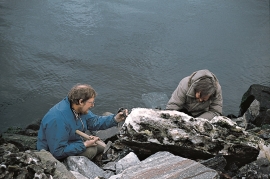
Kvernapollen
When the workers came to Kollsnes to start on the work with the landing for the gas terminal from the Troll field in the North Sea, they found the ruins of an old farm mill at Kvernapollen.