- Remove Quarns and mills filter Quarns and mills
- Remove Late glacial filter Late glacial
- Remove Landscape filter Landscape
- Remove Large landforms filter Large landforms
- Remove Hardanger og Voss filter Hardanger og Voss
- Remove Avalanches and rock falls filter Avalanches and rock falls

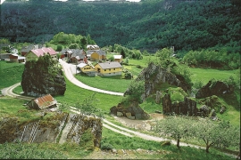
Fruo
At Fruo, nature has built its own little "Chinese wall ". Some kilometers south of the Vøringsfossen waterfall, there are a number of moraine ridges, the longest and most notable of their kind in Hordaland.

Hæreid- geology
The Eidfjord terrace is a gigantic ridge that reaches up more than one hundred metres from the city centre in Eidfjord. It serves as a powerful natural monument left behind by the ice when it retreated.


Måbødalen- geology
The old pack road had 1500 steps, where cars today gas through the mountain. The time of this hard work is over, and of getting used to the steep terrain, as well; only the view from the top is much the same as before. Vøringsfossen in summer is one of Western Norway’s biggest natural wonders. It marks the transition between the older, open part of the Sysendalen valley and the younger, narrow and winding valley of Måbødalen.

Skjervet- river theft
At the end of the last ice age the ice flowed out of Hardanger fjord in such a fury that it forced the meltwater from Voss to run back uphill toward Granvin. The glacier from Raundalen down the windy valley along the Vosso to Bolstadøyri went too slow to make the turn.

Rallarvegen
They rest there, all as one, the silent witnesses of Western Norway's saga of creation: Precambrian basement, phyllite and thrust sheet. In the end came the glaciers and sculptured the vast landscape. Along the ground or on the horizon, from bicycle or on foot - the landscape tells its story - and it tells it clearer on Rallarvegen than many other places.

Mundheim
At Mundheim there is a dangerous stretch of the highway. The mountainside has given way several times in this area. Typically, it happens in the spring, when the frost has loosened its grip.

Tokagjelet
There is a sharp transition between the wide valley at Kvamskogen and the narrow Tokagjelet. The transition is no less dramatic when we come out of the crooked tunnels far down in the canyon, and the open Steinsdalen valley spreads out before us. The canyon both separates and joins together different epochs in western Norway's history.

