- Remove Quarns and mills filter Quarns and mills
- Remove Bergen filter Bergen
- Remove Urban environments filter Urban environments
- Remove Lakes, rivers and river networks filter Lakes, rivers and river networks
- Remove Factories filter Factories
- Remove Burial mounds filter Burial mounds
- Remove Voss, frå 2020 del av nye Voss herad. filter Voss, frå 2020 del av nye Voss herad.

Alvøen
Alvøen is one of the oldest industrial places in Norway. As early as the 1620s a gunpowder mill was built here. The place itself was well situated for industrial activity, lying only 100 m from the waterfall, which provided power for the mill, and a good harbour wherefrom the products were shipped. The success of the gun-powder mill varied in the 1600s and 1700s, but what made Alvøen best known was its paper production.

Bryggen
In the 1300s Bergen was a trading centre of European dimension. The town is thought to have had around 7000 inhabitants and was the largest and most important in the country. In a European context it was an average size town. At this time the most tightly built town area was still mostly east of Vågen from Holmen in the north to Vågsbotn in the south. Already in medieval times, latest in the 1340s, this area was called Bryggen.

Byrkjehaugen
On the farm Bø, close to the highway between Bulken and Voss lies Byrkjehaugen, one of the largest burial mounds in West Norway. Originally it was around 50m across and 5m high, but following the excavation in 1908 and chipping off by both railway and road construction, the cross-section has shrunk to 37m and the height to 4m. All the same, it is an impressive burial monument for the passing traveller to see.
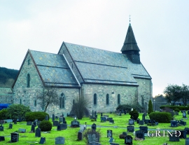
Fana church
In the Middle Ages the stone church in Fana was a place for pilgrimage, containing a miraculous silver crucifix that could heal the sick. A hill to the west of the church is still called Krykkjehaugen (the crutch hill); according to belief this is where the sick threw away their crutches. Perhaps this church, lying where it does at the old half county boundary , also held a special position in relation to the district churches in the county.


Nordåsvatnet
The Post-war Era came to Fana with its population growth and modern sanitary equipment. This had nearly catastrophic consequences for Nordåsvatnet as a recreational area. After the runoff water got re-directed to deeper water, and later also to the fjord outside, Lake Nordås won back both its swimming guests and its sports fishermen.

Rekvemylna
If you enter the farmyard at Rekve, some kilometres from Bulken, where the road departs to Giljarhus, you no longer meet “the miller”, Knut Hernes, in his old rural mill. But some years ago he would wish you welcome, friendly and hospitable, and show you around his mill, which had been his workplace for a generation. As light-footed as a youth he climbed in steep ladders high up into the waterfall, to let the water down on to the waterwheel.


Salhus
Salhus has been a connecting point for sea travellers far back in time. The name probably derives from the Old Norse word sáluhús, “house for travellers”. The name may indicate that this was a place for an inn even in the Middle Ages. The place is eminently situated in the route to and from Bergen. For travellers coming by boat from Sogn and Nordhordland, Salhus is the last stop before Bergen. Travellers from the communities in Voss also came this way earlier when they were going to Bergen

Sandviken
Close to the tunnel opening at Amalie Skrams vei in Ssandviken, there is a cultural monument of European dimensions; a rope making works that produced rope and fishing tackle for West and North Norway.

