- Remove Quarns and mills filter Quarns and mills
- Remove Voss (tidl. kommune) filter Voss (tidl. kommune)
- Remove Hill forts filter Hill forts
- Remove Small landforms filter Small landforms
- Remove Rock carvings filter Rock carvings
- Remove Sunnhordland filter Sunnhordland
- Remove Glaciers filter Glaciers

Bondhusdalen
The Bondhus area in Maruanger has been a magnet for tourists ever since the stream of tourists to Norway's west coast began in the middle of the 1800s. The magnificent landscape with the "ice trail" up to Bondhusvatnet Lake, the ice falls from Bondhusbreen glacier and Keisarstigen trail up to Folgefonna are still popular tourist attractions.

Bordalsgjelet
Deep down between the stone polished phyllite bedrock in Bordalsgjelet canyon, there is a cascading river. In close cooperation with hard polishing stones, the water has carved into the bedrock for thousands of years - and is still doing so today.

Borgåsen
In Etne there are no less than four defensive refuges. They are all situated in strategic positions, so that they have served as places of refuge and protection for central parts of the district

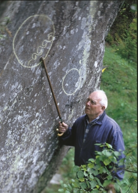
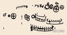

Helgaberget
Helgaberget – the holy hill – is a little rocky crag which thrusts itself a few metres above the terraced surface of Støle. The surface of the rock is strewn with figures inscribed in the rock and it was, as far as one can judge, a cult centre in the Bronze Ages. The name could indicate that the tradition of holiness can have lasted for almost 3,000 years.


Mosnes
The permanently-protected Mosneselva River, with its meltwater from Folgefonna, runs out into Åkra Fjord by the roadless and uninhabited Mosnes. Those who once lived here were forced to surrender to the ravages of Nature. In the autumn of 1962 there was a flood so great that the people were driven from their farms.

Rekvemylna
If you enter the farmyard at Rekve, some kilometres from Bulken, where the road departs to Giljarhus, you no longer meet “the miller”, Knut Hernes, in his old rural mill. But some years ago he would wish you welcome, friendly and hospitable, and show you around his mill, which had been his workplace for a generation. As light-footed as a youth he climbed in steep ladders high up into the waterfall, to let the water down on to the waterwheel.

