- Remove Quarns and mills filter Quarns and mills
- Remove Churches filter Churches
- Remove Civil servant dwellings and manors filter Civil servant dwellings and manors
- Remove Trading posts and guesthouses filter Trading posts and guesthouses
- Remove Austrheim filter Austrheim
- Remove Wetland filter Wetland
- Remove Osterøy filter Osterøy
- Remove Odda, frå 2020 del av nye Ullensvang kommune. filter Odda, frå 2020 del av nye Ullensvang kommune.
- Remove Stord filter Stord
- Remove Mineral resources filter Mineral resources
- Remove Large landforms filter Large landforms

Hamre Church
Hamre Church has, by all accounts been one of the four main churches in Horda County in the Middle Ages. Hamre was a main church for the whole of Hordaland. Timber remains in the present church show that there was a stave church here in medieval times.

Herlandsnesjane
Herlandsnesjane, a four-kilometre long peninsula in Lake Storavatnet in the middle of Osterøy, is well known among botanists. Here lies an unusually large and diverse bog.

Hosanger church
On Christmas Day 1795, at 5 a.m., the lightning struck the church in Hosanger. After three hours, the timbered church from the 1600s, which had replaced the stave church from the Middle Ages, was in ashes. Already on New Years Day in 1796, a sermon was held for the Hosanger population in the main church at Hamre, to which the congregation belonged earlier,

Huglo
The majority of Huglo is bare rock. A bit of dwarf pine forest is the only vegetation able to put down roots. Along the west- and east sides, to the contrary, the landscape is unusually green and lush. The reason lies both in the bedrock and in the ice that covered the area 12 000 years ago.


Kattnakken–Stovegolvet
The highest mountainous area on Stord, including Kattnakken, Midtfjellet and Stovegolvet, has more in common with the mountainous terrain on the mainland than in the low coastal landscape of Sunnhordland. The volcanic bedrock together with the erosive powers of nature has resulted in a unique plateau landscape.
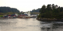
Kjelstraumen
If you take the sea route north you have several options. The various routes have been dealt with in history, and through the Middle Ages the traffic increased as well as the trading with Nordland in fish and herring, feather and down. One of the central routes passes through Kjelstraumen, in the sound between Ulvøy and Bakkøy. This has been a place for a guesthouse since 1610, with Royal Letter of Privilege, part of the large network of trading post and guesthouse locations along the coast.


