- Remove Smallholdings filter Smallholdings
- Remove Conservation area filter Conservation area
- Remove Defense filter Defense
- Remove Thrust sheets filter Thrust sheets
- Remove Voss, frå 2020 del av nye Voss herad. filter Voss, frå 2020 del av nye Voss herad.
- Remove Churches filter Churches
- Remove Fish filter Fish
- Remove Samnanger filter Samnanger


Gullbotnen
A barren belt where almost nothing grows, runs through the forest on the east slope of Gullbotnen. But, along the west side of the main road there is a fertile zone that flourishes with several finicky plant types. The contrasts arise from the extreme variations in the nutrient content of the bedrock.

Ådland
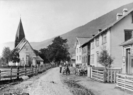
Ådland, innermost in the Samnanger Fjord is an old church centre and transport centre; a nodal point in the transport from sea to land. The white painted church standing today, was built in 1851, but there were two older churches here in former centuries.


Hamlagrø
The type of underlying rock can be decisive for how many different types of plants are found in an area. In the area around Hamlagrø-lake the diversity is especially obvious. The geological conditions change much here within a short distance.

Lønaøyane
The Strandaelvi river is forever protected from the development of hydropower. The Lønaøyane islands – which comprise the delta furthest north in Lake Lønavatnet - are a part of this water system. In 1995 the level of protection for the Lønaøyne islands was strengthened to that of a nature preserve because of the rich birdlife in this wetland.

Nordheim
"And here these endless kingdoms and these toils for a rich working life far and wide have lain and slept for a hundred thousand years! Right up until the Voss Railway came in 1883 and woke them, like the prince in the fairytale who awakened the Sleeping Beauty."

Rekvesøyane
The sediment that was deposited from the river Dyrvo has created the fan-shaped delta Rekvesøyane. The bit of land farthest out toward the water gets periodically flooded, especially during snow melt and after periods of much rain.
Vangskyrkja
Vangskyrkja (Vangen church) is the largest of the medieval churches in Hordaland; one of the four “fjordung” churches in the county. A royal letter from 1271 shows that the church was under construction at this time. Vossevangen at Vangsvatnet, where the wide and expansive valleys of the Voss communities meet, was the natural location for a church.

