- Remove Smallholdings filter Smallholdings
- Remove Burial mounds filter Burial mounds
- Remove Etne filter Etne
- Remove Late glacial filter Late glacial
- Remove Farm sites filter Farm sites
- Remove Delta filter Delta
- Remove Rock carvings filter Rock carvings
- Remove Iron age filter Iron age

Borgåsen
In Etne there are no less than four defensive refuges. They are all situated in strategic positions, so that they have served as places of refuge and protection for central parts of the district

The village of Etne
Much of the sand and gravel that the town of Etne is built on was laid down at the end of the Ice Age and is evidence of melting glaciers and roaring meltwater rivers. The uncompacted material in the big terraces leave their unmistakeable mark on the wide elongated valleys.

Etnedeltaet
During the latter half of the 1900s the big natural river deltas on Westland disappeared. Until the 1980s there was still a small, but significant remnant of the original river delta from the Etneelva river, but today most of this, too, is industrial land.

Helgaberget
Helgaberget – the holy hill – is a little rocky crag which thrusts itself a few metres above the terraced surface of Støle. The surface of the rock is strewn with figures inscribed in the rock and it was, as far as one can judge, a cult centre in the Bronze Ages. The name could indicate that the tradition of holiness can have lasted for almost 3,000 years.

Skånevik- moraine
In Skånevik there are marks left from the ice edge that advanced during the thousand-year cold spell (Younger Dryas) that marked the end of the Ice Age roughly 11 500 years ago. The glacier first proceeded out into Åkra Fjordand and around Vannes and thereafter sent an arm in toward Skånevik. Here, the glacier lay down an end moraine up against the mountainside.

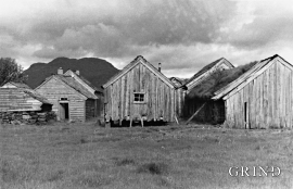
Sæbøtunet
When you come into the well-tended farm steading at Sæbø just above Etne centre, you get the impression of a Sunnhordland farm from well before the time of the tractor; from the time of the horse and the scythe. The hamlet at Sæbø, one of the farms neighbouring to Gjerde, was taken over by Sunnhordland Folk Museum in 1938.

