- Remove Smallholdings filter Smallholdings
- Remove Fish filter Fish
- Remove Sediments filter Sediments
- Remove Masfjorden filter Masfjorden
- Remove Os, frå 2020 del av nye Bjørnafjorden kommune filter Os, frå 2020 del av nye Bjørnafjorden kommune
- Remove Ulvik filter Ulvik

Rallarvegen
They rest there, all as one, the silent witnesses of Western Norway's saga of creation: Precambrian basement, phyllite and thrust sheet. In the end came the glaciers and sculptured the vast landscape. Along the ground or on the horizon, from bicycle or on foot - the landscape tells its story - and it tells it clearer on Rallarvegen than many other places.

Ulvik-village
The ice cap that covered the land during each of the 40 past ice ages over the past 2 million years of Earth's history pressed down the crust of the earth - like a finger on a rubber ball. And when the ice finally loosened its grip 11,000 years ago, the earth's crust rose again, most where the ice was thickest, least where it was thin, quickly in the beginning, and later more slowly. To this day, the land in the inner part of Norway continues to rise by perhaps one millimetre per year. By and large, however, the crust in Hordaland has again reached equilibrium after the weight of the ice was removed.


Lysekloster- The monks and nature
Lysekloster was the largest agricultural property in the country when it was phased out during the Reformation in 1537. In its prime this cloister encompassed two-thirds of all the farms in Os. The monks introduced and cultivated new plant species and it was probably they who stocked the waters with fish not indigenous to the area. This legacy from the Middle Ages has left a lasting mark.

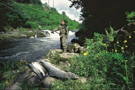
Oselva
Oselvo is the biggest waterway on the Bergen peninsula, with sources in Gullfjellet and Sveningen. There is a fall of only 60 metres along the entire stretch from Samdalsvatnet Lake to the sandbank in Fusafjorden. It is rare to see a river like this in western Norway. There is salmon along this entire section of the Oselvo river.


