- Remove Smallholdings filter Smallholdings
- Remove Vernacular crafts filter Vernacular crafts
- Remove Seabirds filter Seabirds
- Remove Place filter Place
- Remove Askøy filter Askøy
- Remove Maritime environments filter Maritime environments
- Remove Avalanches and rock falls filter Avalanches and rock falls
- Remove Churches filter Churches
- Remove Eidfjord filter Eidfjord
- Remove Late glacial filter Late glacial
- Remove Fitjar filter Fitjar
- Remove Austrheim filter Austrheim
- Remove Cultural landscapes filter Cultural landscapes
- Remove Voss, frå 2020 del av nye Voss herad. filter Voss, frå 2020 del av nye Voss herad.
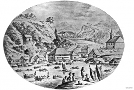
Strusshamn
On the south side of Askøy, just west of Bergen, lies Strusshamn. The sheltered bay is one of the best harbours in Byfjorden, on the route south. At the time of the sailing ships the harbour could be full of vessels from Bergen and abroad, lying in wait for favourable wind. Old anchoring rings from 1687 bear witness to this. Strusshamn was a quarantine harbour for ships that came sailing in with the yellow pest flag flying.

Krossøy
Furthest north in the island community Rongevær, at the entrance to Fensfjorden, lies Krossøy. Belonging to the farm are the islands of Krossøy, Husøy, Kårøy, Lyngkjerringa, Søre Kjerringa, Rotøy and Kuhovet. All of them have been inhabited. On Krossøy itself today there are four holdings. The marine use environment here is one of the best preserved along the West Norwegian coast.

Evanger
Evanger (from Old Norse ålvangr, “vang”, “voll” (field) where the horses may graze) is the place where the river from Vangsvatnet, the Voss watercourse, runs out into Evangervatnet. From here Teigdalen valley runs to the north, towards Eksingedalen, and from here there is a short distance to Bergsdalen in the south.
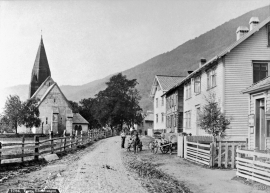
Vangskyrkja
Vangskyrkja (Vangen church) is the largest of the medieval churches in Hordaland; one of the four “fjordung” churches in the county. A royal letter from 1271 shows that the church was under construction at this time. Vossevangen at Vangsvatnet, where the wide and expansive valleys of the Voss communities meet, was the natural location for a church.

Eidfjord church
The old stone church at Eidfjord has an open position on the terrace at Lægreid. In a diploma from 1310 it transpires that Torgeir on Sponheim donated a gift for the erection of the church in Eidfjord. Thus we can assume that the church was under construction at the time. The elements in the style confirm such a dating.

Fruo
At Fruo, nature has built its own little "Chinese wall ". Some kilometers south of the Vøringsfossen waterfall, there are a number of moraine ridges, the longest and most notable of their kind in Hordaland.

Hæreid- geology
The Eidfjord terrace is a gigantic ridge that reaches up more than one hundred metres from the city centre in Eidfjord. It serves as a powerful natural monument left behind by the ice when it retreated.


Herdla – glacial deposits
The shift in the landscape is striking between the barren craggy moors north on Askøy and the green fields of Herdla, which has the county's biggest farm. The majority of Herdla, such as the island appears today, is a gift from the glacier: The glacier that advanced here over 12,000 years ago stopped at the northern tip of Askøy and took its time building up the moraine on Herdla. Since then, Herdla has been under continual transformation. The re-organisation of the loose sediment deposits continues today.
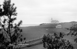
Herdla Church
A letter from the Pope Eugenius 3 in 1146 mentions St. Nikolaus church at Herdla. This church belonged under Munkeliv monastery, which was founded in Bergen by Øystein around 1110. The Herdla Church may stem from this time.

