- Remove Smallholdings filter Smallholdings
- Remove Basement rocks filter Basement rocks
- Remove Fedje filter Fedje
- Remove Maritime environments filter Maritime environments
- Remove Avalanches and rock falls filter Avalanches and rock falls
- Remove Churches filter Churches
- Remove Eidfjord filter Eidfjord
- Remove Late glacial filter Late glacial
- Remove Os, frå 2020 del av nye Bjørnafjorden kommune filter Os, frå 2020 del av nye Bjørnafjorden kommune
- Remove Defense filter Defense
- Remove Vaksdal filter Vaksdal
- Remove Introduced species filter Introduced species

Fruo
At Fruo, nature has built its own little "Chinese wall ". Some kilometers south of the Vøringsfossen waterfall, there are a number of moraine ridges, the longest and most notable of their kind in Hordaland.

Hæreid- geology
The Eidfjord terrace is a gigantic ridge that reaches up more than one hundred metres from the city centre in Eidfjord. It serves as a powerful natural monument left behind by the ice when it retreated.


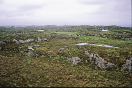
Fedje bog
The wild rabbit is really native to Northwest Africa, but the Ancient Romans introduced them to large parts of Europe. Not to Norway, rightly enough: the population on Fedje originated from 3-4 pairs that were brought here from the Shetland Isles in 1875, making this their first residence in the country.

Vinappen
Vinappen lies on a low hill to the very west on the island. Here you have an amazing panorama of the sea. Originally the area was grazing land for cattle, but this changed when the Germans occupied the island. Just before WWII there was a small bearing station, used by the Norwegian Coast Artillery in connection with exercises at sea.

Eksingedalen- landscape
Eksingedalen alternates between wide, flat flood plains with good farmland, and narrow passages with waterfalls where the roads cling to the mountainsides. The alternations in the landscape are a result of the sculpturing work by glaciers over several ice ages, and the deposition of the glacial river deposits when the last glacier finally melted back.


