- Remove Vernacular arts filter Vernacular arts
- Remove Defense filter Defense
- Remove Hardanger og Voss filter Hardanger og Voss
- Remove Nordhordland filter Nordhordland
- Remove Lakes, rivers and river networks filter Lakes, rivers and river networks


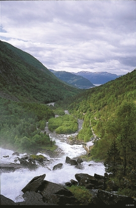
Eksingedalen- hydropower development
Water discharge at the outlet of the Ekso into Eidsfjord was halved after the big hydropower development in the mountainous area between Modalen and Eksingedalen and further southward toward Evanger in the 1960s, 70s and 80s. In an attempt to amend the changed environmental conditions in the waterway the developer built 35 small dams in the river.

Ekso
In the late 1800s, Ekso was known among the nobility in England as having among the best salmon rivers. In summer the Lords could haul in big fish of up to 25 kg. In return, the townsfolk were paid for fishing rights, lodging and local assistance.

Frøyset river network
Frøyset river network is protected from power station-building - not because of its pristine nature - but because it is a typical river network for this part of western Norway.

Granvinsvassdraget
After the ice age, Granvin Fjord reached all the way up under Skjervsfjossen waterfall. Just a thousand years later, as a result of the rising of the land after the ice melted, this whole inner part of the fjord freed itself of the sea and became Granvinsvatnet lake. In spite of this rise in elevation, this waterway is still navigable for fish: Sea trout have wandered into Granvinsvatnet in more recent times and evolved to become freshwater trout. And salmon and sea trout made the journey 13 kilometres up the Storelvi river.

Huse
The farm Huse is situated on a broad terrace in the valley above the church and the commons ground in Kinsarvik. Huse is one of the largest farms in Kinsarvik. The house from the Middle Ages, still standing at Huse today, probably from the middle of 1200, is joined on to a house in the Swiss style from around 1890. This house, with a smoke-vent in the roof, bears witness of a grand old farm and of the chieftain’s power in early medieval times.

Håøy
Håøy lies centrally in one of the main shipping lanes going into Bergen --- with Håyøsund on the south side facing Meland, and Hagelsundet facing Lindåslandet. Names like Nordfarskista and Nordfarsskorane explain things. The strategic position was important in Viking times and it has been important in our days too. The beacon on Håøy can have been built in the establishment of the coastal administration in Håkon the Good’s time, about 950 AD. The defence structure of which we say remains on Håøy Summit held a critical position during Norwegian neutrality during the First World War. The defence structure was taken down in 1957.