- Remove Museum filter Museum
- Remove Etne filter Etne
- Remove Boat- and shipyards filter Boat- and shipyards
- Remove Fitjar filter Fitjar
- Remove Coniferous forests filter Coniferous forests
- Remove Mountain plants filter Mountain plants
- Remove Sveio filter Sveio
- Remove Sediments filter Sediments

Årskog
Årskog farm is situated in a typical coastal landscape in a gentle terrain that slopes down from the outlying heaths down towards the fjord. The farm steading exists as it was in the 1800s. In 1980 the two brothers, Lars and Olai Årskog donated the farm with all its contents of tools and interior decoration, for museum purposes.

The village of Etne
Much of the sand and gravel that the town of Etne is built on was laid down at the end of the Ice Age and is evidence of melting glaciers and roaring meltwater rivers. The uncompacted material in the big terraces leave their unmistakeable mark on the wide elongated valleys.


Fitjar- potatoes
The deep agricultural soils in Fitjar are found especially in the area between Lake Storavatnet and Breivika. The many stonewalls in the area reflect that the earth probably was full of stones and stone blocks. The stones that couldn't be dug out had also a function: they stored heat that helped to grow potatoes.

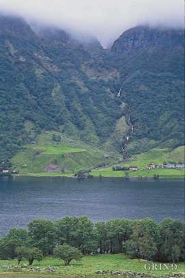
Grønafjellet
Mountain plants with their beautiful, colourful flowers are common in high altitude areas in Norway. On the coast there are not so many of them. But, here and there one nonetheless finds mountain plants, and this makes some coastal mountainsides a little bit different. Perhaps the growth on these mountainsides gives us a little glimpse of a distant past?

Hopsfjellet
On June 2nd, 1992, a big forest fire broke out in Sveio. The fire started southeast of Hopsfjellet. In a strong wind the flames spread quickly northward. Houses on the other side of the highway were threatened, but escaped unscathed. The burned area, which is easily visible about a 5 minute's drive south from the tunnel at the triple- junction, was made into a nature reserve in 1998. The intention was to ensure that the re-establishment of plant- and animal life would take place without disturbance.

Skånevik- moraine
In Skånevik there are marks left from the ice edge that advanced during the thousand-year cold spell (Younger Dryas) that marked the end of the Ice Age roughly 11 500 years ago. The glacier first proceeded out into Åkra Fjordand and around Vannes and thereafter sent an arm in toward Skånevik. Here, the glacier lay down an end moraine up against the mountainside.