- Remove Small landforms filter Small landforms
- Remove Place filter Place
- Remove Sediments filter Sediments
- Remove Boat- and shipyards filter Boat- and shipyards
- Remove Churches filter Churches
- Remove Igneous rocks filter Igneous rocks
- Remove Conservation area filter Conservation area
- Remove Ullensvang, frå 2020 del av nye Ullensvang kommune. filter Ullensvang, frå 2020 del av nye Ullensvang kommune.
- Remove Fitjar filter Fitjar

Fitjarøyane
If we study the group of islands south of Selbjørns Fjord from the air or on a sea map, we will notice that many of the islands are elongated and lie systematically in rows. The islands are divided by long sounds, for example Trollosen, Nuleia and Hjelmosen, which are oriented in a south-southeast to north-northwesterly direction.

Fitjar- potatoes
The deep agricultural soils in Fitjar are found especially in the area between Lake Storavatnet and Breivika. The many stonewalls in the area reflect that the earth probably was full of stones and stone blocks. The stones that couldn't be dug out had also a function: they stored heat that helped to grow potatoes.

Rimbareid- Vestbøstad
At nesting time you cannot avoid hearing the calls of the curlew or the snipe along the narrow road through the cultural landscape from Rimbareid to Vestbøstad. And on late summer evenings, the intense song of the sedge warbler rings out over the two characteristic tarns in the area.


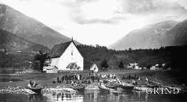
Ullensvang church
Ullensvang church, situated beside the vicarage, in idyllic surroundings on the headland just inside Lofthus municipality, is mentioned for the first time in written sources in 1309. At that time the present Gothic stone church must have been new. Judging by the style in the western portal and the eastern chancel windows, the church must have been built around 1300 or just before, probably by builders from Bergen influenced by the English Gothic style.
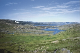
Veivatnet
From Kinsekvelven river and inward to Lake Veivatnet, we can wander through one of Hardangervidda's many fertile areas. A number of finicky plants grow here, and there are plenty of birds and fish. We can thank a lime rich soil for the diversity.
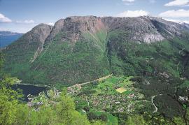
Kinsarvik church
By all accounts the church in Kinsarvik must have been one of the four main churches in the old Horda County. The stone church standing today was restored by cathedral architect Chr. Christie in 1880, and again by Peter Helland-Hansen in 1960-61. At that time an archaeological investigation was undertaken, which has unearthed new knowledge about the church.

