- Remove Small landforms filter Small landforms
- Remove Cultural landscapes filter Cultural landscapes
- Remove Ulvik filter Ulvik
- Remove Kvam filter Kvam
- Remove Literature filter Literature
- Remove Churches filter Churches
- Remove Trading posts and guesthouses filter Trading posts and guesthouses
- Remove Chieftains and royal lines filter Chieftains and royal lines
- Remove Fjell, frå 2020 del av nye Øygarden kommune filter Fjell, frå 2020 del av nye Øygarden kommune
- Remove Austevoll filter Austevoll
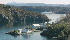
Bakholmen
On Austre Bakholmen, a small islet of around 15 acres between Hundvåko and Drøni, lies the oldest trading centres in Austevoll. For a long time this was a court location and it was a natural centre in this archipelago.

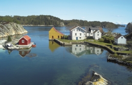
Krosshamn
Krosshamn lies in the shipping lane northeast of Hundvåkøy, near Sandtorv. The name probably derives from the fact that this is Austevoll’s harbour situated nearest to Korsfjorden.
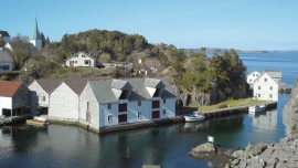
Kvalvåg
Kvalvåg on Stolmen is first mentioned as a trading post in 1655, and in 1731 the owner Jens Meyer, was granted a royal trading privilege.


Jomfrunuten
Freezing and thawing are processes that influence plant cover, move enormous blocks, stretche long mounds of earth, break open bedrock and create patterns in stone and earth.

Osa
At the bottom of the Osa fjord there is a cultural landscape marked by great contrasts; the wide terraces and the river delta at the fjord contrast with the steep hillsides in the background, where Norddalen leads up to the mountain. There are two farms here. Osa and Sævartveit – the farm at the river mouth and the hollow by the sea.


Brattholmen
The old guesthouse location in Brattholmen on the east side of Litlesotra, was probably established in the first half of the 1700s. A list from 1748 mentions that the place “for some years has been inhabited by an Enrolled Sailor by the name of Peder Michelsen”. As was the case for most other military hosts, he was exempt from paying income tax.

