- Remove Small landforms filter Small landforms
- Remove Cultural landscapes filter Cultural landscapes
- Remove Ulvik filter Ulvik
- Remove Kvam filter Kvam
- Remove Monastery filter Monastery
- Remove Farm sites filter Farm sites
- Remove Lindås, frå 2020 del av nye Alver kommune. filter Lindås, frå 2020 del av nye Alver kommune.
- Remove Archaeological findings filter Archaeological findings
- Remove Eidfjord filter Eidfjord

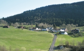
Botnen
Fyksesundet and Botnagrenda present a fine experience of the landscape and cultural history; a geographically isolated local settlement with extensive cultural contact with the outside world.

Frøystein
The farm Frøystein by the Ulvik fjord is commonly called Fryste. In 1614 the name was written Frøstemb – an obvious Danish influence – and the form Frøsten was used up until the land register in 1886 and 1907. It is probable that the name of the farm originally was Frystvin; a vin-name. Thus it has no connection with neither Frøy (Norse fertility god) nor stein (stone).

Halne
At Halnefjorden, a few hundred metres east of Halne mountain lodge, lie the remains of two stone sheds – Halnelægeret. Some generations ago the cattle drovers stopped here in the summer; they were the cowboys of their time. But Halnelægeret already had a long history before the cattle drovers came.


Hjølmo
In the steep hillside in Hjølmodalen, a small side valley from Øvre Eidfjord (Upper Eidfjord), which has been a key entrance to the Hardanger Plateau, the hamlet of old farmhouses still lie clustered together. The yard is empty today, some of the houses are used in the summer, but the grass grows round all the corners.

Hæreid- archaeology
The biggest prehistoric burial site in Hordaland is situated at Hæreid. On top of the terrace expanse, inside the fine birch garden, is where they lie, the mounds and stone piles, on their own or in clusters, large and small, round and elongated – at least 350 in all.
Isdal
Isdal one of the few clustered settlements left in the Hordaland communities, after the extensive changes taking place around the turn of the former century, which broke up the shared farms and the old intermixture of strips. The old, low houses are situated in a compact enclosure, which is very noticeable in the landscape when you travel the main road north from Knarrvik.

Jomfrunuten
Freezing and thawing are processes that influence plant cover, move enormous blocks, stretche long mounds of earth, break open bedrock and create patterns in stone and earth.

Kjeåsen
High up above the fjord, at a height of 600m lie the two holdings at Kjeåsen. Today you can drive there by car, through a new tunnel that the power engineers in Sima have drilled. Until 1974 the only road went up the steep hillside, along iron bolted ladders across dizzying rocks – a road for the strong at heart.


