- Remove Small landforms filter Small landforms
- Remove Cultural landscapes filter Cultural landscapes
- Remove Ulvik filter Ulvik
- Remove Kvam filter Kvam
- Remove Metamorphic rocks filter Metamorphic rocks
- Remove Radøy, frå 2020 del av nye Alver kommune. filter Radøy, frå 2020 del av nye Alver kommune.
- Remove Monastery filter Monastery
- Remove Avalanches and rock falls filter Avalanches and rock falls

Jomfrunuten
Freezing and thawing are processes that influence plant cover, move enormous blocks, stretche long mounds of earth, break open bedrock and create patterns in stone and earth.

Osa
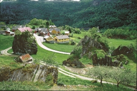
At the bottom of the Osa fjord there is a cultural landscape marked by great contrasts; the wide terraces and the river delta at the fjord contrast with the steep hillsides in the background, where Norddalen leads up to the mountain. There are two farms here. Osa and Sævartveit – the farm at the river mouth and the hollow by the sea.


Toska
The peat bogs on Toska have been mined for peat since 1946, when the island got electricity. In this treeless coastal landscape, peat was the most important source of energy, and this took quite a toll on the bogs.

Vågenes
On Vågenes, on one of the prominences out toward Eitrevågen, one finds garnets in anorthosite. The garnets are both older, and not least bigger, than average.

Botnen
Fyksesundet and Botnagrenda present a fine experience of the landscape and cultural history; a geographically isolated local settlement with extensive cultural contact with the outside world.

Mundheim
At Mundheim there is a dangerous stretch of the highway. The mountainside has given way several times in this area. Typically, it happens in the spring, when the frost has loosened its grip.

Nes
The farm Nes lies directly inside Mundheim on a forested headland in the fjord between Mundheimsvika and Bondesundet, a farm with an attractive and well-kept cultural landscape.

